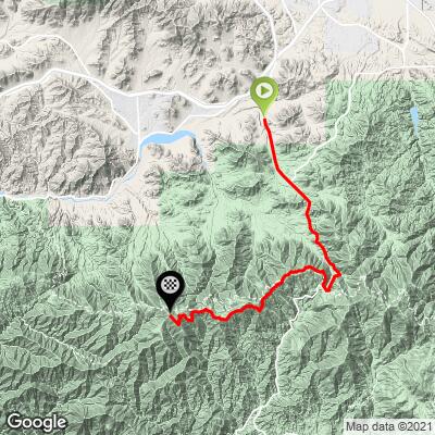
Mt. Gleason North (Nike Missile Site) Bike Climb - PJAMM Cycling

4.6
FIETS
17 mi
DISTANCE
3,856 ft
GAINED
3.7 %
AVG. GRADE

FULL CLIMB STATS

INTRO

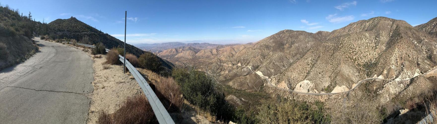
Ride up to an abandoned Cold War Nike Missile launch site. 

See more details and tools regarding this climb's grade via our interactive Profile Tool.
Roadway:
The surface of Angeles Forest Hwy is excellent. Traffic is light, but cars and motorcycles tend to drive fast around turns. 
The traffic significantly reduces once you turn onto Mt Gleason Road (mile 7.8) but the pavement quality declines. 

Parking:
There is a paid parking lot for a train station near the start of the climb. If you'd rather park at the summit, there are scenic pullofs along Angeles Forest Hwy that are fine to park at for a few hours. An Angeles Forest recreation pass is required to park at a campsite, trailhead, or day-use site. 
This climb is unsupported. There are Fire stations along the ride that have public use water fountains/bottle fillups (but from our experience, it's a 50-50 chance that the water is turned on). 

Clear Creek Fire Station (not along route - water is always on)
Before heading out on any cycling adventure check out our Things to Bring on a Cycling Trip and use our interactive check list to ensure you don't forget anything.
Check out our full ride suggestions in the Full Summary to plan your next ride around Mt Gleason.

Although Gleason is one of our local favorites and absolutely worth spending a day to ride, if you're traveling to LA to climb, we actually recommend focusing most of your efforts on rides like Glendora Mountain RoadHwy 39 - Dawson SaddleCrystal Lake, and even rides across town in Malibu (ocean views!)  To get to these the best place to stay is farther east in Glendora, and to get to the latter, Malibu has some top hotels. If you plan on doing more than just riding while in LA, Santa Monica is our recommendation. 

ROUTE MAP

MEMBER RATING

Not Yet Rated
-
Road
-
Traffic
-
Scenery

CURRENT WEATHER

PJAMM TRIPS ADVENTURE STARTER BUNDLES

Check out PJAMM Adventure's prepackaged (self-guided) cycling trips. They will help you plan, document and conquer your next adventure.
ALL TRIPS
Browse all of our prepackaged trips and find your next adventure!
San Gabriel Mountains
United States (CA)
38 ROUTES
43 POIs
ROUTE STATS (TOTAL)
677.5
mi
DISTANCE
80,483
ft
ELEV. GAIN

NEARBY CLIMBS (0) RADIAL PROXIMITY

FROM
No Climbs Found

MEMBER REVIEWS & COMMENTS

Let us know what you thought of this climb. Signup for our FREE membership to write a review or post a comment.
Already have an account?
ROUTE MAP
PROFILE TOOL
Route Data
S.G. (%)
hide
Segment Data
hide

Climb Profile Not Found
CLIMB SUMMARY

Unlike the approach from the south where you ride along the lushly vegetated Monte Cristo Creek, the approach from Palmdale is a true desert setting.

The turnoff onto Mt Gleason road at Mill Creek Summit, the highest point along Angeles Forest Road (4,920 ft).

It looks like there’s another road climb to the south, but the pavement only continues for another ¼ mile before turning into a respectable gravel climb: https://www.strava.com/segments/15838516 

Once you reach the north side of the mountain, the views open up and go from average to absolutely spectacular - wide open views of desert plains and mountains looking towards Las Vegas.  

6 miles into Mt Gleason road you stumble upon an old Nike Missile site. Project Nike (named after Nike the winged Greek goddess of victory) was a U.S. Cold War military operation designed to protect major US cities from foreign nuclear missiles.  A Nike missile would launch from these sites (scattered about remote places in the US) and destroy the enemy warheads in midair before they reached their target.

(photo source: wikipedia)

These missiles have since been removed and decommissioned, and these launch sites remain as historical attractions.

 A giant fuel tank for the missiles.

After the missile site, the steepest part of the climb remains: 2.4 miles at 8.3%, with individual grades reaching the mid-teens. The summit is in clear view!

There’s a brief (~100 yd long) downhill section of dirt after the missile site  before the pavement resumes. After the missile site, the pavement gets a bit worse and much more overgrown, but never terrible, considering the last time it was paved (in the 1950s?) - you can still cruise on the descent.

After a 2 mile stretch of agonizingly steep pavement, there’s a right turn up to the last remaining trees on the summit.

Looking back down at the Nike Missile site.

We love these pure summit finishes for the 360 degree views - note the santa monica mountains, Santa Catalina Island poking through the fog, and the late afternoon sunlight reflecting off the Pacific Ocean.