

4.7
PDI
17.9 mi
DISTANCE
2,008 ft
GAINED
0 %
AVG. GRADE
FULL CLIMB STATS
INTRO
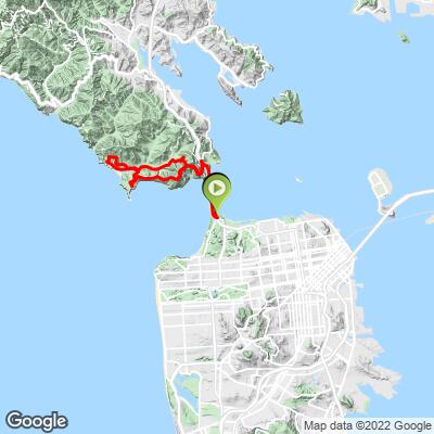
Most people who ride across the Golden Gate Bridge stop at Vista Point, take the photo and turn around. Keep going and the Marin Headlands hand you one of the best short loops in the Bay Area: 17.9 miles (28.8 km) from the south end of the bridge and back, with 2008 ft (612 m) of climbing spread over three hills - the city on one side of the ridge, open Pacific on the other.
The first hill is Hawk Hill itself, up Conzelman Road from the bridge to the high point of the road, about 815 ft, the bridge dropping away behind you. Then, instead of turning around, the loop drops off the far side on the one-way, downhill-only stretch of Conzelman, a quarter mile of it close to 18%, aimed straight at Point Bonita and the ocean. Field Road carries you down past the Nike missile site and the Marin Headlands Visitor Center to Rodeo Lagoon, and our route throws in a detour most riders miss - up through the old barracks of Fort Cronkhite and a car-free military road to Battery Townsley, built in 1940 for two 16-inch guns, before dropping to Rodeo Beach.
The hardest part comes last. After an easy spin east through Rodeo Valley on Bunker Road, McCullough Road climbs back to the Conzelman roundabout - a mile at about 8.3%, steeper than anything on the bridge side - and the route keeps going, up Conzelman to the top of Hawk Hill a second time. Only then do you get the long, fast roll down to the bridge and the crossing home with the city in front of you.
The one-way descent decides the direction for you. Go on a weekday morning if you can - the bridge sidewalk and Conzelman are both far calmer before the tourists arrive - and bring a layer whatever the forecast says, because fog and wind can change this ride in ten minutes.
PLAN YOUR ROUTE
 We've partnered with Sherpa-Map.com to bring you the best route planning tool. With a PRO Membership you can use this climb as a reference when creating your route.
See more details and tools regarding this climb's grade via our interactive Profile Tool.
Roadway: No dirt anywhere on the loop. The bridge sidewalk is concrete and shared with people on foot: 15 mph limit, 5 mph around the towers, pedestrians first. Which sidewalk you use changes with the day and the hour (the full schedule is on our Hawk Hill page) - in standard time (November to mid-March) that means the west sidewalk only on weekends and holidays, until 6:30 p.m. On the Marin side the route ducks under Highway 101 from Vista Point to Alexander Avenue and turns up Conzelman. Past the top of Hawk Hill, Conzelman is one-way downhill to Field Road, and the park opens that stretch (roundabout to Field Road) only from 6 a.m. until an hour after sunset. Field, Bunker and Mitchell roads are ordinary two-way park roads. The Battery Townsley detour climbs Kirkpatrick Street through Fort Cronkhite onto an old paved military road closed to cars - narrower, slower and shared with hikers - and comes down to the Rodeo Beach lot. The park's own Marin Headlands map shows that stretch of the Coastal Trail as open to bikes; on trails the limit is 15 mph, and 5 mph on corners and when passing hikers. McCullough Road is two-way, twisty and has no shoulder. The Golden Gate Half Marathon closes roads and lots here from 2 to 10 a.m. on November 1, 2026.
Traffic: The bridge is the slow part, not the roads: on a sunny weekend afternoon the sidewalk is a weave through walkers, photo stops and rental bikes. Lower Conzelman fills with cars hunting for parking at Battery Spencer. On the one-way side every car is going your direction. Bunker Road carries the beach traffic to Rodeo Beach, which gets crowded on warm weekends, and McCullough carries cars both ways between Bunker Road and Conzelman, so hold your line through its bends.
Parking: For the full loop, use the bridge South lot by the Welcome Center; the North lot at Vista Point works for a Marin-side start. The Rodeo Beach lot at mile 10.0 is another option and has restrooms and a water fountain, but it fills early on nice weekends. The park keeps a standing auto-theft warning up for its lots and overlooks - take your phone, wallet and keys with you.
Gear: Any road bike will do; the steepest climbing tops out around 10% for a few hundred yards. Brakes matter more than gears here - you're braking hard on the near-18% one-way, again coming off Battery Townsley at around 8%, and for 1.7 miles down Conzelman to the bridge at the end. Dress for three climates in one ride: the bridge can be windy and cold even on a sunny day, the Headlands can be socked in, and Rodeo Valley can be warm and still. A vest or thin jacket and a rear light for the fog are the two things we never leave behind on this loop.
Provisions: Eat and drink at the start - there's nothing to buy in the Headlands. The Round House cafe (Equator Coffees) by the south bridge lot opens 9 a.m. to 6 p.m. on weekdays and 8 a.m. to 6 p.m. on weekends, and the Golden Gate Bridge Welcome Center next door is open 9 a.m. to 6 p.m. daily. On the loop, the Rodeo Beach lot at mile 10.0, just before the long run up to McCullough, has restrooms and a water fountain - the one dependable refill on the route.
Before heading out on any cycling adventure check out our Things to Bring on a Cycling Trip and use our interactive check list to ensure you don't forget anything.
When to go: Weekday mornings for an empty bridge and an empty Conzelman. Fog is the wild card: it can hide the bridge from the bridge, and summer is fog season on this side of the bay. Late-afternoon rides are lovely, but remember the one-way side closes an hour after sunset, so don't start a sunset loop late.
Worth stopping for: The Nike missile site on Field Road (a restored Cold War launch site, open Saturdays 12:30 to 3:30 p.m.), Battery Townsley at the top of the Fort Cronkhite detour (the park runs occasional open houses inside), and Rodeo Beach itself. For the hawk watch, Battery Spencer and the Point Bonita Lighthouse schedule, see our Hawk Hill page.
Shorter or longer: Skip the Battery Townsley detour and you save about 320 ft of climbing. Want to skip McCullough too? From Bunker Road you can head east through the Baker-Barry Tunnel to Alexander Avenue - a single car lane on a long timed signal (each direction gets roughly five minutes) with bike lanes along both walls. To stretch it, roll down to Sausalito: the new Vista Point Trail, opened in fall 2026, links Vista Point with lower Conzelman Road and Fort Baker so you don't have to ride the fast Alexander Avenue off-ramp. Keep going north and you can make a real day of it on Golden Gate - Mt. Tam - Astro. With wider tires, the Headlands fire roads are right there: Bobcat Trail and Marincello both start a few minutes from the loop.
ROUTE MAP
MEMBER RATING
CURRENT WEATHER
PJAMM TRIPS ADVENTURE STARTER BUNDLES
Check out PJAMM Adventure's prepackaged (self-guided) cycling trips. They will help you plan, document and conquer your next adventure.
NEARBY CLIMBS (0) RADIAL PROXIMITY
FROM No Climbs Found
MEMBER REVIEWS & COMMENTS
Let us know what you thought of this climb. Signup for our FREE membership to write a review or post a comment.
Already have an account?
LOG IN HERE
