13.8
PDI
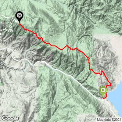
10.9 mi
DISTANCE
2,779 ft
GAINED
4.7 %
AVG. GRADE
FULL CLIMB STATS
INTRO
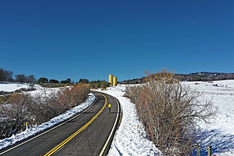
Cycling Palomar Mountain East Grade: This is the easier of the two routes to the top of Palomar Mountain. While the wildly popular Palomar Mountain South Grade is on busy Highway 168 for the first five miles, the route from the east is peaceful and on a country road with little traffic.
PLAN YOUR ROUTE
Average grade of 4.6% (5.4% climb only) 40% (4.4 miles) are at 0-5% and 47% (5.1 miles) at 5-10%. The steepest quarter mile is 9.1% and steepest mile 7.2%.
See more details and tools regarding this climb's grade via the “Profile Tool” button above.
Roadway: Good shape as of 2019.
Traffic: Mild.
Parking: Most cyclists do not do just Palomar Mountain East, but if you are, there is parking on the side of the road overlooking the Lake Henishaw Dam a few hundred yards up from the start of the climb. Map; Street View.
Provisions: There is a the Palomar Mountain Store and Mother's Kitchen Restaurant 4/10's of a mile past the finish of the climb. Map; Street View. We love Mother's Kitchen and highly recommend it.
Before heading out on any cycling adventure check out our Things to Bring on a Cycling Trip and use our interactive check list to ensure you don't forget anything.
Other climbs in the area include the most popular bike climb in San Diego County, Palomar Mountain South Grade, Cole Grade Road, and the epic Nate Harrison Grade. The out-and-back for the two Palomar climbs is 48 miles with 7,590' of climbing (Map). Also see our San Diego County and Southern California climb pages for great bike climbs in the region. When staying in San Diego County, there are plenty of options for hotels or vacation rentals, depending on your preference.
Use the “Routes in Area” button on the menu bar above to see other bike climbs in this area.
ROUTE MAP
MEMBER RATING
CURRENT WEATHER
PJAMM TRIPS ADVENTURE STARTER BUNDLES
Check out PJAMM Adventure's prepackaged (self-guided) cycling trips. They will help you plan, document and conquer your next adventure.
NEARBY CLIMBS (0) RADIAL PROXIMITY
FROM No Climbs Found
MEMBER REVIEWS & COMMENTS
Let us know what you thought of this climb. Signup for our FREE membership to write a review or post a comment.
Already have an account?
LOG IN HERE
Clarence


My go-to Palomar climb (I live in San Diego County). Park at the Lake Henshaw Resort (first picture) - a large parking lot with no hassle. The start of the climb from there is down highway 76 3/4 mile and a right turn. Extremely light traffic with good, wide pavement (as of 2024). After the summit there is an intersection where you can 1) descend South Grade, 2) continue out to the top of Nate Harrison Grade, or 3) continue East to the Palomar Observatory. Also at this intersection is a store (locally called Mother's, second pic) which is not reliably open, but a source of water and food. Otherwise there is water at both state parks, one near Nate Harrison Grade and the other at the foot of the climb up to the observatory. The roads on top are wide and have been mostly repaved as of 2024 - excellent places to get more climbing in and enjoy the mountain air. Traffic is very light and for the most part cycling-respectful.
golmstead
This is my favorite route up to Palomar Mountain. It's the easiest of the three routes, but the scenery is nice and the traffic is light. I park at the Lake Henshaw Resort, then descend for a mile or so before turning off the Hwy and onto the climb. At the summit there is building with a bathroom next to the Post Office. The bathroom has a faucet for filling up bottles. The descent on East Grade is great because you use brakes only sparingly.
Clarence
You brake down East Grade?? :-)