McNeil Canyon Road Bike Climb - PJAMM Cycling

15.4
PDI
6 mi
DISTANCE
2,370 ft
GAINED
7.5 %
AVG. GRADE

FULL CLIMB STATS

INTRO

This is a fairly isolated bike climb that begins along the Columbia River at a fruit packing plant 170 miles east of Seattle in north central Washington.  We are quickly out of the commercial area and into the rolling hillside with no visual obstructions (or shade) - nothing but pastureland, hills and some occasional pine trees along the way.  Although not the most beautiful climb around, it is a great workout and bike ride. 

"McNeil Canyon is a very solid climb in central Washington near scenic Lake Chelan that takes you out of the mighty Columbia River gorge. Fairly steep to start, a flat soon greets you. Solid climbing then resumes for over a mile before easing again and becoming variable..." (This quote is presented with the approval of John Summerson, from his book, The Complete Guide to Climbing (by Bike), 2nd Edition, pg. 225.)
The grade on this climb is 7.5% with next to no descent.  30% of the climb (1.8 miles) is at 0-5% grade, 41% (2.4 miles) is at 5-10%, 26% (1.6 miles) is at 10-15%, and 1.8% (0.1 mile) at 15-20% grade. The steepest quarter-mile of the climb is 13.5% and steepest continuous mile 11.3%.

Use the “Routes in Area” button in the menu to see what other climbs are in the area. 
Roadway:  2 lane road in excellent condition and a shoulder to ride in most of the climb. 

Traffic:  Light. 

Parking:  At the fruit packing plant - Map Street View. 
Provisions:  None on the route, but there are plenty of spots to get food and beverages in Chelan 5 miles northwest (Map to Chelan from start)
Before heading out on any cycling adventure check out our Things to Bring on a Cycling Trip and use our interactive check list to ensure you don't forget anything.
Along with Mission Ridge and Badger Mountain Road, this is one of three Top 10 Washington climbs within 40 miles of the each other.  McNeil Canyon Road is the fifth hardest bike climb in the state of Washington. 

This is a fairly remote climb but there are some hotel/motel options in the area.  There are also some cabin and condo rentals you could choose from.  

MEMBER RATING

Difficulty: Strenuous
5
Road
4
Traffic
3
Scenery

CURRENT WEATHER

PJAMM TRIPS ADVENTURE STARTER BUNDLES

Check out PJAMM Adventure's prepackaged (self-guided) cycling trips. They will help you plan, document and conquer your next adventure.
ALL TRIPS
Browse all of our prepackaged trips and find your next adventure!
Olympic NP: Hurricane Ridge
United States (WA), Canada
8 ROUTES
19 POIs
ROUTE STATS (TOTAL)
125
mi
DISTANCE
14,009
ft
ELEV. GAIN

NEARBY CLIMBS (0) RADIAL PROXIMITY

FROM
No Climbs Found

MEMBER REVIEWS & COMMENTS

Let us know what you thought of this climb. Signup for our FREE membership to write a review or post a comment.
Already have an account?

Apr 20, 2021
In the pre-Covid era, this climb was included in the Chelan Century Challenge.
Apr 8, 2021
difficulty: Strenuous
scenery: 3
traffic: 4
road: 5
Apr 8, 2021
scenery: 3
traffic: 4
road: 5
I did this climb on 7th April 2021 (along with Badger Mountain- see entry). I parked at the Beebe PUD park, located on the west side of US 97, immediately south of the Beebe Bridge, and directly across from the beginning of McNeil Canyon road. There's ample parking there and bathrooms (park hours 08:30-20:00 as of the time of this writing). The Lone Pine store is located 6 miles south of the parking, and has great sandwiches plus some produce, and good coffee (Blue Star from Twisp). Not open on Sunday as of April 2021, but pre-Covid, it was open 7 days a week, so good to call first. The climb pretty unrelenting (you can see the profile). The main issue is wind. I had a decent tailwind to start (which really doesn't help much given the steepness). But, by the time I reached the summit, it had become very strong, gusty and unpredictable. I had to pedal down many of the 12-16% grades, and thought I might get blown over a couple times.
ROUTE MAP
PROFILE TOOL
Route Data
S.G. (%)
hide
Segment Data
hide
CLIMB SUMMARY

Cycling McNeil Canyon - Washington’s 6th hardest bike climb

Ride 6 miles gaining 2,390’ at 7.5% average grade.

The McNeil Canyon bike climb is the 6th hardest in Washington State.

Climb begins by riding up McNeil Canyon Road from Hwy 97 and the Columbia River.

Photo:  Beebe Bridge and the Columbia River

The Columbia River is the 4th largest by volume in the US and has the greatest flow of any river in the US that empties into the Pacific Ocean.

Off Hwy 97 across from Beebe Bridge Park is McNeil Canyon Rd   The ride starts with gentle terrain for about 1 mile where you make your way to where the climb starts at Chelan Fruit Plant 3  Soon this gentle terrain turns into a beast with road sign warning you the next 5 miles are at 12%.  It is rated as a "Cat 1"climb!   At least the road surface is nicely paved   Be prepared because it offers little or no shade and cell service.

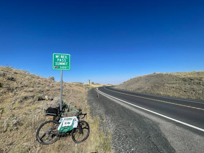
Riding 6 miles at average of 7.5% grade you’ll appreciate reaching the McNeil Pass Summit 3100 foot sign.  While there, take time to look back at the beautiful view of Columbia River

McNeil Canyon Road is the signature climb in the Chelan Century Challenge hosted by Rotary Club in May