Mt. Baldy Notch (from Lytle Creek) Bike Climb - PJAMM Cycling

33.8
PDI
11.2 mi
DISTANCE
4,485 ft
GAINED
7.6 %
AVG. GRADE

FULL CLIMB STATS

INTRO

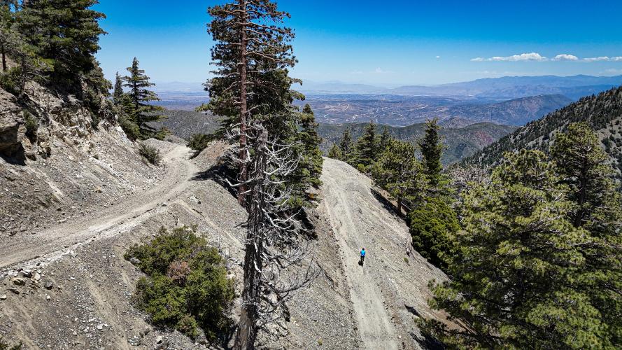
This is an epic climb to the Baldy Notch, high above the finish of the paved portion of the Mt. Baldy Climb and is a top 25 US gravel climb.

Check out the other and more popular side of the gravel pass - Mt. Baldy (to the Notch)

See more details and tools regarding this climb's grade via our interactive Profile Tool.
This is a great gravel-bike road. There are a couple sections where the gravel gets bigger, but never too big that suspension or walking is necessary. Unlike many climbs in the area, where the road gets really chunky towards the top,, the surface stays gravel-bike friendly at high elevations.

Parking in Lytle Creek will require a paid San Bernardino National Forest day pass, so we recommend parking at the base somewhere like Nealey's Corner or Coyote Canyon Park
Don't let the alpine views fool you - this very much feels like a desert ride, especially in the summer. Everything is dry and dusty with almost no shade (even higher up when you're among the trees), so bring plenty of water and electrolytes.

You'll pass a few campgrounds and general stores in the towns of Lytle Creek and Scotland early on in the ride. The next provisions doesn't come until the climb's finish at the Top of the Notch Restaurant, the ski lodge that operates on weekends in the summer. 
Before heading out on any cycling adventure check out our Things to Bring on a Cycling Trip and use our interactive check list to ensure you don't forget anything.
Information Not Available

If you have any information regarding this climb, we'd like to hear from you. Click the CONTRIBUTE button to share your thoughts with us.
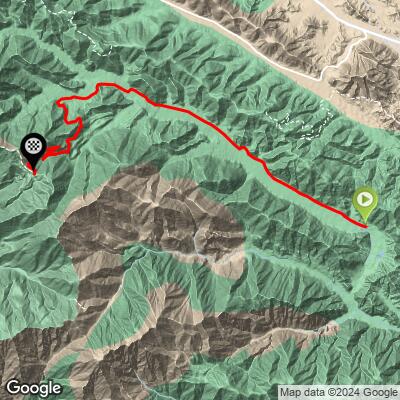
ROUTE MAP

MEMBER RATING

Not Yet Rated
-
Road
-
Traffic
-
Scenery

CURRENT WEATHER

PJAMM TRIPS ADVENTURE STARTER BUNDLES

Check out PJAMM Adventure's prepackaged (self-guided) cycling trips. They will help you plan, document and conquer your next adventure.
ALL TRIPS
Browse all of our prepackaged trips and find your next adventure!

NEARBY CLIMBS (0) RADIAL PROXIMITY

FROM
No Climbs Found

MEMBER REVIEWS & COMMENTS

Let us know what you thought of this climb. Signup for our FREE membership to write a review or post a comment.
Already have an account?
ROUTE MAP
PROFILE TOOL
Route Data
S.G. (%)
hide
Segment Data
hide

Climb Profile Not Found
CLIMB SUMMARY

Mt. Baldy to the Notch (From Lytle Creek)

Ride Date:

June 2024

What we rode:

Scott Addict

Our tires:

Front: 45 mm Pirelli Cinturato (knobby)

Rear: 40 mm Pirelli Cinturato, (knobby)

What tires we recommend:

As big of tires as you can run

What is the surface like?

This is a great gravel-bike road. Unlike many climbs in the area, where the road gets really chunky towards the top, the surface stays gravel-bike friendly at high elevations. There are a couple sections where the gravel gets bigger, but never too big that suspension or walking is necessary.

Mile 3.5

Mile 8.3

Mile 10.8


Climb summary by PJAMM’s Sam Lyons @sam.lionman

I’m going to be honest here. I love climbing on my bike. On any surface - tarmac, gravel, dirt, it’s what I live for. But the first part of this climb was a real slog.

A buddy and I started out at 7am out of Heritage Park near the bottom of Mount Baldy Road. Our goal was to document this climb as a part of a full loop: 50 miles starting in Rancho Cucamonga, riding east to Lytle Creek, up to the notch, then descending the front side of the Notch down Mt Baldy Road back to the car. 7am ended up being too late, because by the time we got up into Lytle Creek canyon it was HOT, and it was a race to get up to altitude where hopefully it’d be breezier and cooler.

After suffering up the paved section (Lytle Creek Road climb) which seems to never end, we reach the shooting range where the gravel starts. It was already above 90 degrees and for some reason I thought that when we reached the dirt, everything would feel better and be easier.

Not so.

The first 3 miles of gravel are a straight slog with no turns at 8% climbing nearly 1200 ft. There is almost no shade, which means that when we passed by Lytle Creek, taking off our shoes and wading in was a no brainer!

You won't have to worry about passing this creek without seeing it since for a short section, it becomes the road!

Eventually we made a tight left around a cliff and reached Stockton Flats Campground, where a few groups of hikers had set up their camps. Comforting to know that while remote, there are still enough people around that you’re never further than a few miles away from help.

Shortly after that we crossed under a gate to keep the Jeeps from accessing the ski resort. At this point you have less than 4 miles left but still 1700 feet to climb…

This is also when the views start to make this ride worth it. If you started from the bottom, which we expect most of you probably will, you will have climbed a minimum of 4,000 feet by this point without seeing anything strictly speaking “spectacular”. But from here on out, it’s an incredible ride:

Towards the top you come across a pair of long hairpins. The top is visible when climbing the last 1000 feet

If you’re not acclimated, this is when the ride will get really tough. Because I’m at elevation quite often, I’m usually not bothered too much by anything under 9 or 10,000 feet. However, when I rode this, it was the first time I’d been above 3,000 ft in about 6 months, and the altitude nearly destroyed me. As the air got thinner nearing 7800 ft summit, every pedal stroke was tough with my eyes glued to my wahoo counting down the feet to go.

At the top is Mt. Baldy Ski Resort - one of the best places to ski in Southern California. Set on the slopes of the 10,000ft Mt. San Antonio, it’s about a 90 minute drive from the ocean, allowing you to snowboard and surf in the same day.  During the summer the lifts operate as a hiker and tourist attraction, bringing people up to the Notch Restaurant where they hold events and live music on the weekends.

6300’ straight uphill with almost 0’ descent definitely earns a cheeseburger and beer!

It’s a wrap!


Links:

Learn about PJAMM’s Surface Index

Learn about PDI (PJAMM Difficulty Index)