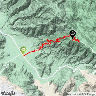
Nate Harrison Grade Bike Climb - PJAMM Cycling

11.7
FIETS
10.3 mi
DISTANCE
4,447 ft
GAINED
8.2 %
AVG. GRADE

FULL CLIMB STATS

Page Contributor(s): Luke Hise, Phoenix, AZ, USA

INTRO

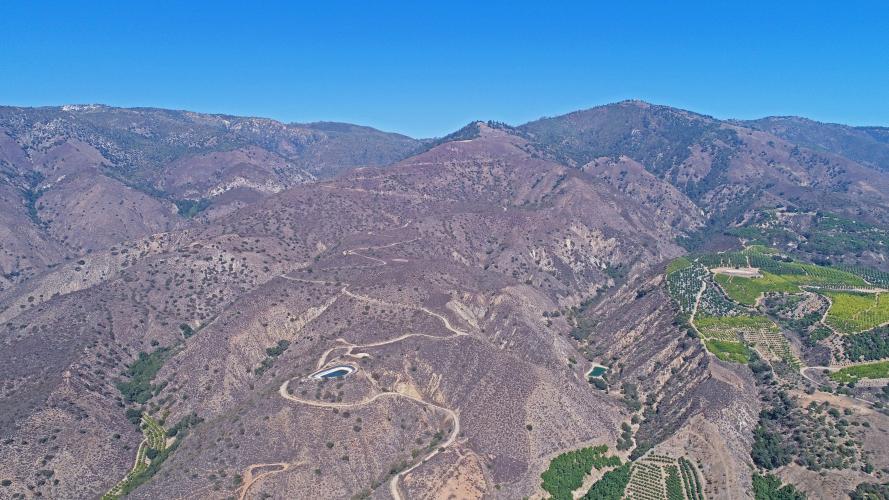
Nate Harrison Grade is the most difficult bike climb in San Diego County (see the PJAMM San Diego Climb Area page for more climbs in the area).  This is an epic bike climb along a mountainside with giant hairpins and excellent views of the Pauma Valley.  Note that much of the climb is dirt and gravel, but manageable (barely) on a road bike with 28mm tires. 
This climb averages 8.2% for its 10 miles.  There is a full 2.5 mile segment that averages 10% beginning near the bottom of the climb at mile 1.6.  54% of the climb is at 5-10% grade and 30% is at 10-15%.  The steepest quarter-mile is 13.1% and steepest mile 10.9%.

See more details and tools regarding this climb's grade via the “Profile Tool” button.
Roadway:  As noted in the introduction, this climb is primarily on dirt and gravel.  I have ridden the climb three times, always on a road bike and it is manageable, but barely so.  I have used 25mm slick, 28mm slick, and 32mm knobby tires and much prefer the knobbies.  

Traffic:  Not a problem - you may not see another motor vehicle the entire climb.

Parking:  I have always parked on the first part of Nate Harrison Grade Road adjacent to the orange groves.  Map; Street View.
A gravel bike is recommended, but I have done the climb three times on a Specialized Roubaix with 25mm slicks, 28mm slicks and 32mm knobbies. 
Before heading out on any cycling adventure check out our Things to Bring on a Cycling Trip and use our interactive check list to ensure you don't forget anything.
This is a remote climb, which I have done by either driving the hour from San Diego on the day of the climb, or staying at Harrah's Casino nearby.   The Pala Casino Spa and Resort is near the climb as well.  

ROUTE MAP

MEMBER RATING

Difficulty: Strenuous
2.3
Road
5
Traffic
4.5
Scenery

CURRENT WEATHER

PJAMM TRIPS ADVENTURE STARTER BUNDLES

Check out PJAMM Adventure's prepackaged (self-guided) cycling trips. They will help you plan, document and conquer your next adventure.
ALL TRIPS
Browse all of our prepackaged trips and find your next adventure!
Palomar Mountain
United States (CA)
4 ROUTES
20 POIs
ROUTE STATS (TOTAL)
42.7
mi
DISTANCE
12,975
ft
ELEV. GAIN

NEARBY CLIMBS (0) RADIAL PROXIMITY

FROM
No Climbs Found

MEMBER REVIEWS & COMMENTS

Let us know what you thought of this climb. Signup for our FREE membership to write a review or post a comment.
Already have an account?

Jul 23, 2021
difficulty: Extreme
scenery: 5
traffic: 5
road: 2
Jul 23, 2021
scenery: 5
traffic: 5
road: 2
I parked at the commuter lot on 76/I15 intersection and forgot how stupid drivers are. Was happy to make the turn onto the grade and start up. This thing is a beast. 4400 feet of poor, high-friction road surface made this a very tough climb. It took me longer to climb this than Onion Valley Road. I should have started a little earlier (or closer) as I was drowning in sweat because of the humidity. I would not want to do it on a road bike with 28s, but my all-road/gravel bike (dual-suspension) was a bit of overkill on the other end. It was super-smooth seated but annoying when you wanted to stand. The scenery was amazing; certain it afforded better views than the Palomar climb on pavement.
Jun 21, 2021
difficulty: Strenuous
scenery: 3
traffic: 5
road: 2
Jun 21, 2021
scenery: 3
traffic: 5
road: 2
This is my first time up this gravel grade. I have previously descended it last fall on my road bike (25mm & rim brakes) and put my guardian angles and brakes to the test! I knew the better way to experience Nate Harrison Grade was to go UP it and not down. The climb is challenging on 25mm but not impossible. You just need to stay seated the whole time to avoid spinning out. Palomar General store awaits you at the top of the mountain to recharge and hydrate. If you're a roadie, best to go down the southern side or take the long ways down the eastern slope.
Apr 28, 2021
difficulty: Strenuous
scenery: 5
traffic: 5
road: 2
Apr 28, 2021
scenery: 5
traffic: 5
road: 2
Been up this climb twice, both times in early fall. Excellent views and hardly any traffic. Flies can be a problem in the woods past 3000 feet. Since it's mostly unpaved and steeper than South Grade, I used my Trek Checkpoint ALR5 gravel bike. 40mm knobby tires and 31/34 gearing really helped. The steep bits are towards the beginning, the worst is a dirt 16% grade that goes for about a quarter mile. After that, just fairly consistently steep with no real sharp kickers. Haven't descended down it, though. Much less margin for error with the steep slope and loose surface and also no guardrails. Went down South Grade each time. Parking at the Harrah's Casino in Rincon is easy and it's a good place to start from.
Mar 29, 2021
difficulty: Strenuous
scenery: 5
traffic: 5
road: 3
Mar 29, 2021
scenery: 5
traffic: 5
road: 3
Very tough climb, there are short stretches of 15%+. Did this in late march, there was a decent amount of mud above 4,500. I used a road bike with 32mm knobby tires and for gears had a compact with 36t in the back. I felt like that was the right setup for this ride. A mountain bike was not necessary (I descended via south grade) as there arent any large rocks or bad sectors, but you do need good gear ratios and some traction
ROUTE MAP
PROFILE TOOL
Route Data
S.G. (%)
hide
Segment Data
hide

Climb Profile Not Found
CLIMB SUMMARY

Drone photo of Nate Harrison Grade and orange groves

Cycling Nate Harrison Grade

Switchbacks dead ahead.  We cycle up and over the mountain center of photo.

Climb summary by PJAMM’s John Johnson.

US Top 10 Most Epic Bike Climb

Drone photo of Nate Harrison Grade and orange groves

    Nate Harrison Grade road sign on Hwy 76 

Drone photo of Nate Harrison Grade and orange groves

The Nate Harrison Grade bike climb is a very steep ride in northern San Diego County, California.  The first mile is paved, but the majority of the climb is on a dirt fire trail with very steep grades.  There is intermittent pavement along the seven mile stretch from miles one through eight, but we would estimate 90% of the climb is gravel and rock with miles five through eight being particularly challenging, with a couple of stretches that are barely manageable on a road bike. We used compact chainring with 30t cassette and 28mm tires on a Specialized Roubaix. Although extremely challenging, it is an epic and private climb. A good description of this ride is found at MountainBikeBill.

Before heading out on your Nate Harrison Grade cycling adventure, be sure to rely on our list of Things to Bring on a Cycling Trip, and use our interactive checklist to ensure you don't forget anything.

Pavement ends sign on Nate Harrison Grade Road bike climb San Diego County 

Pavement ends at mile 1.1 but picks up again at mile 8.

Do not trespass sign while cycling up Nate Harrison Grade.  

No one has suggested this is not a public road --

we think the “no trespass” means don’t go off the road.


Early morning -- our goal today:  Nate Harrison Grade early a.m., then on to

Poppy Apocalypse Lake Elsinore + Gibraltar, Santa Barbara

Spectacular backdrops to this ride: Pauma Valley in background with Pacific Ocean beyond.

Harrison Serenity Ranch at mile 6.5.

Note in the mailbox at Harrison Serenity Ranch.

It’s all about the hairpins and views on Nate Harrison Grade.

Over 20 hairpins + spectacular views of Pauma Valley and Pacific Ocean on a clear day.

Pauma Valley and Pacific Coast: 25 miles on straight line in the background.

Can Nate Harrison Grade be ridden on a road bike?:  Yes. In 2014 and again in March 2019 we road Nate Harrison Grade on road bike (2014) and road and cross bikes (2019).  In 2014 we rode with compact chainring + 28t and 28mm tires and did not descend; it was a tough climb, but manageable.  In 2019 we used a Specialized Roubaix (compact chainring + 42t cassette + 32mm knobby tires) and a Specialized Crux cross bike (28t chainring + 42t cassette + 38mm tires) and did descend.  It was easier getting up on the bike in 2014 than descending in 2019.  We recommend for the average but fit cyclist (one of us was 34 and an exceptional cyclist, the other 62 and average but fit cyclist) at least:

  • Compact chainring.
  • 30t cassette or bigger.
  • 30mm tires or bigger.
  • Descending with a mountain bike is not preferred.  We prefer the Nate Harrison Grade Loop which we did in 2014.

The old man’s bike used in March 2019.

Compact chainring, 42t cassette, 32mm knobs in back, 30mm road tires in front.

We apologize for the shaky video, but it IS bumpy, after all . . .

Shot before the DJI OSMO  😒

If it’s any consolation, this is the roughest spot and is manageable on a road bike.

Update:  2-10-21 - Luke Hise, Phoenix, AZ writes:  I rode Nate Harrison yesterday. Early season conditions exist. The top dirt section was mtn bike only on account of the snow mediated mud. The first dirt section and the middle paved section all appeared manageable with a wide road bike tire. However, some of the steeper switches were loose and I had traction issues on my full suspension mountain bike with 2.5” tires.  Furthermore, there will be mandatory rock slalom for anyone on a road bike. Overall, I would say that the climb is doable on a road bike with one caveat . I am concerned the top section will be chewed up once it dries. The mud ruts were robust already. And finally, the grade is not to be descended by anything save a mountain bike. See Luke Hise slideshow via “Photos & Videos link just below the featured image for this page.

The Short Story:  We LOVE Nate Harrison Grade and strongly recommend this climb; just be sure to bring the right bike setup and gear.  There are no provisions on the climb, but if you don’t descend and take the Nate Harrison Grade Loop linked above, you must stop at Mother’s Kitchen at the top of the Palomar Mountain climb (12.6 miles into the loop).

Mile 12.6 of the Nate Harrison Grade Loop.

We prefer the pastries but they do have main courses, too.

Beware the flies - Greg Matherly of Encinitas writes “ The only thing that sucks about NHG are the flies or fleas or whatever they are. Especially if it’s hot. And it seems they have gotten worse over the years. They torment the shit out of you! I carry a net I throw over my head when I get near the wooded areas.”

An excellent history of Nate Harrison Grade is found at San Diego Travel Tips - Nate Harrison Grade Page:

Nate Harrison Grade is approximately 12.5 miles east of the I-15 on Pala Road/CA-76. If you didn't know it, you'd drive right by it to explore Pauma Valley, Harrah's Rincon Casino and Mt. Palomar. Rather than taking the beaten path, make the turn onto Nate Harrison Grade road and you'll be in for a treat. Another obscure treat that we feel compelled to tell you about.

Who was Nate Harrison?  Nate Harrison (1823-1920) a former slave, is known as the first African-American settler in San Diego County. The stories of his age, life and when he took residence on the mountain run the gamut. Stories suggest he was on the mountain as early as 1850 but artifacts tend to indicate it was closer to the 1890's. The truth is probably somewhere in the middle. He came to the area during the Gold Rush and made the mountain his home. His roadside property stood along the only road up and down the mountain. He would provide water and rest to all those who made the journey up or down the mountain. He befriended all and shared stories, made up stories, and became a legend in those parts and subsequent to his death in 1920.

Read the full history here. 

We have ridden Palomar Mountain five times and Nate Harrison Grade twice.  On two trips we stayed at Harrah’s Casino (we don’t gamble, BTW) in the Pauma Valley which is just a few miles from the start of each climb.  Rates are reasonable and they have a gas station and Subway shop next to the Casino.

Harrah’s as seen looking south, five miles from the start of the climb.

SOUTHERN CALIFORNIA’S TOP BIKE CLIMBS

Top Southern California Road Bike Climbs - clockwise from top left to middle:

Nate Harrison Grade, San Diego; Gibraltar Road, Santa Barbara; Palomar Mountain, San Diego

Glendora Mountain Road, Los Angeles; Mt. Baldy, Los Angeles

Access to full Climb Summary requires a PJAMM Cycling PRO Membership!

It takes less than a minute to sign up & with your PRO membership you can:
  • Rate climbs, post comments and share your experiences on any of our climb pages
  • Create bucket lists of climbs & mark the dates you complete them
  • Weather data for all climbs - Start & Finish
  • Upload photos to your member page to customize your PJAMM Cycling experience
  • Utilize all of our interactive tools - Profile & Routes in Area
  • Download climb route .gpx files
LEARN MORE
SIGN UP

Already have an account? LOG IN HERE