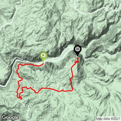
Glacier Point Bike Climb - PJAMM Cycling

4.9
FIETS
25 mi
DISTANCE
4,614 ft
GAINED
2.5 %
AVG. GRADE

FULL CLIMB STATS

Page Contributor(s): Luke Hise, AZ

INTRO

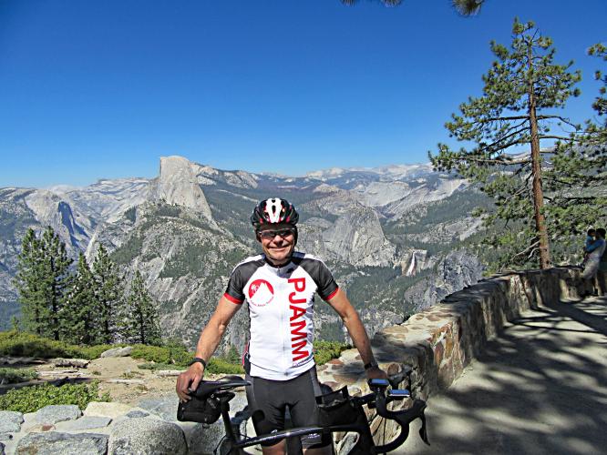
The Glacier Point bike climb is one of the most scenic bike climbs in California, the US, and the world - along the way there are exceptional viewpoints of El Capitan, Half Dome, Vernal, and Nevada Falls. Glacier Point is the hardest and longest bike climb in and around Yosemite National Park. 

For an excellent guide to attractions in Yosemite National Park see Yosemite NP Travel Guide.
Because of several descents on this route (one at -3.2% for 2.5 miles and another at -5.5% for 2.2 miles to the finish at Glacier Point - a must) the average grade reads as 2.4%, but eliminating the descents raises the true grade of the climb to 4.7%.  Nowhere is the climb terribly steep - the steepest quarter-mile is 8.5% and steepest continuous mile 6.2%.  Less than 1% of the climb is at ≥10% grade.
 
See more details and tools regarding this climb's grade via the “Profile Tool” button above.
Roadway:  Excellent condition. You may have the chance to ride Glacier Point Road without any vehicle traffic.  From National Park Website for Tioga and Glacier Point Roads, "In some years, these roads may be open during limited periods to bicycles prior to opening to cars. Any updates regarding pre-opening access on these roads will appear on this webpage. Unless otherwise posted here, both roads are closed to cyclists if they are closed to vehicles."  

Traffic:  Moderate-Heavy in Yosemite Valley and mild on Glacier Point Road beginning at mile 9.2.

Tunnel: There is a 0.8 mile tunnel at 5% at mile 1.5 - bring lights!!

Parking:  Closest parking to the start is Bridalveil Fall lot - Map; Street View.  Also reference Google Parking Map.
Provisions - There no provisions along the route.  There are water faucets, snacks and beverages at the Glacier Point Visitor Center (Google Map + Reviews).

Lights:  rear lights (and preferably front as well) for the .9 mile uphill tunnel at beginning at Tunnel View if you intend to ride through the tunnel.  Best to ride the tunnel early if you are going to do it.  Beware on the descent through the tunnel as it may have patches of wetness. 
Before heading out on any cycling adventure check out our Things to Bring on a Cycling Trip and use our interactive check list to ensure you don't forget anything.
See our Yosemite National Park page for cycling tips about Yosemite.  There are 3 extraordinary viewpoints you will want to stop at along the climb: Tunnel View 1.6 miles up from the start (Google Map + Reviews; Street View), Washburn Point - 7/10ths of a mile from the finish of the climb (Google Map + Reviews), and Glacier Viewpoint at the climb finish, 1/10th of a mile easy hike from the Glacier Point Visitor Center (Google Map + Reviews; Street View). 

The best "action" cycling photo in Yosemite NP is at Glacier Point Curve Vista just 1/4 mile from the finish (Map; Street View). Tip: Have someone stand inside the hairpin and photograph you riding by with Half Dome in the background - Epic Photo!

Check out the best hikes in Yosemite.

There are many hotels and vacation rentals in the Yosemite area, inside & outside the park.

ROUTE MAP

MEMBER RATING

Difficulty: Challenging
4
Road
5
Traffic
4
Scenery

CURRENT WEATHER

PJAMM TRIPS ADVENTURE STARTER BUNDLES

Check out PJAMM Adventure's prepackaged (self-guided) cycling trips. They will help you plan, document and conquer your next adventure.
ALL TRIPS
Browse all of our prepackaged trips and find your next adventure!
Yosemite National Park
United States (CA)
29 ROUTES
33 POIs
ROUTE STATS (TOTAL)
376
mi
DISTANCE
42,565
ft
ELEV. GAIN

NEARBY CLIMBS (0) RADIAL PROXIMITY

FROM
No Climbs Found

MEMBER REVIEWS & COMMENTS

Let us know what you thought of this climb. Signup for our FREE membership to write a review or post a comment.
Already have an account?

Apr 27, 2021
difficulty: Challenging
scenery: 4
traffic: 5
road: 4
Apr 27, 2021
scenery: 4
traffic: 5
road: 4
Bikes only! Be in position to get out on this climb as soon as the snow is plowed and before they open it up to cars. Usually a 3-10 day window in April or May. Climb is long but low grade so relatively easy. Mostly wooded throughout but once you get to the end the view is epic! Must do while closed to cars!
May 22, 2021
Don’t be wary of the warnings there are no places to get water. There are at least 5 streams that water can be collected from. Only things needed are a water filter and water purifier.
ROUTE MAP
PROFILE TOOL
Route Data
S.G. (%)
hide
Segment Data
hide

Climb Profile Not Found
CLIMB SUMMARY

Cycling Yosemite - drone photo of Yosemite Valley, El Capitan and Half Dome

Yosemite Valley: El Capitan + Half Dome

View from Washburn Point, Yosemite National Park

US Top 10 Most Scenic Bike Climb

For more Yosemite climbs, visit our Cycling Yosemite National Park page.

Climb summary by PJAMM’s John Johnson.

The Glacier Point bike climb is the best climb in and around Yosemite Valley.  It is long at 25 miles and affords 3 of the greatest viewpoints in the entire park (Tunnel View, Washburn Point, Glacier Point).  There are a few descents along the way, most notably 2.6 miles of -3.1% (descending 442’) beginning at mile 15 and the last 3.5 is 2 descending segments with a ½ mile ascent in between.  The high point of the climb is at mile 21.4 (7,800’) but it would be ill advised to turn back there - continue on to Washburn and Glacier Points - these are extraordinary viewpoints and lifetime experiences.

Before heading to Yosemite for your cycling adventure, be sure to rely on our list of Things to Bring on a Cycling Trip, and use our interactive checklist to ensure you don't forget anything.

Photo:  Left - Washburn Point 1 mile from finish at Glacier Point

Photo right:  Glacier Point.

Cycling Glacier Point - collage of half dome, cyclist, bike, el capitan

Photos clockwise from top left:  

Western entrance (Hwy 120); just past view from start of Glacier Point Road;

View from Washburn Point; View just past tunnel;

Half Dome from Glacier Point

If you are visiting Yosemite Valley, be sure to get up to Tunnel View, Glacier and Washburn Points which are three of the best viewpoints in Yosemite.  Interestingly, while the National Park Service page for Glacier Point lists multiple transportation modes to get there, cycling is not on the list (see “Warning and Caution,” below).

Bicycle ride up to Glacier Point - view from Tunnel View - El Capitan and Half Dome

Yosemite Valley: El Capitan, on the way to the start. 

Yosemite National Park was created in 1890, is 748,436 acres, and averages 4,336,000 visitors a year. Yosemite was initially protected via the Yosemite Grant signed by Abraham Lincoln. The park (including the great El Capitan and Half Dome) is in the Cathedral Mountains of the Sierra Nevada Mountain Range. These granite monoliths were formed by glacial movement millions of years ago.

Bicycle ride up to Glacier Point - view from Tunnel View - El Capitan and Half Dome

View from Tunnel View at mile 1.5 of the Glacier Point climb.

Cycling Glacier Point - view from inside tunnel at Tunnel View - Half Dome and El Capitan 

A real Tunnel View!

Warning:  Bring taillights!

Pushing my luck . . .

Not a problem at 3 a.m.  🙂

The National Parks Service writes of Tunnel View:  “Tunnel View provides one of the most famous views of Yosemite Valley. From here you can see El Capitan and Bridalveil Fall rising from Yosemite Valley, with Half Dome in the background. This viewpoint is at the east end of the Wawona Tunnel along the Wawona Road (Highway 41)”  National Park Service - Tunnel View.

Viewpoint just past the tunnel.

Bicycle ride up to Glacier Point - view from Tunnel View - El Capitan and Half Dome

Turn left off of Wawona Road onto Glacier Point Road at mile 9.2.

The high point of the climb is a couple miles before Washburn and Glacier Points, but we strongly recommend continuing the journey to the end, which includes riding your bike the short distance (100 yards or so) from the Glacier Point Gift Shop and Store to Glacier Point. There is no water from the Valley floor for 24 miles to the Glacier Point Store, so come prepared with plenty of water and provisions for a several hour, 24-mile journey.  There is a gift shop and store at Glacier Point.

Cycling Glacier Point - Washburn Point sign

Washburn Point is one mile from the finish and is an exceptional viewpoint.

Sunrise at Washburn Point

Photo from PJAMM’s 6/28/18 Bike Valley Floor to Glacier Point + hike to top of Half Dome.

The National Park Service writes of Glacier Point:

Glacier Point, some would say, is the most spectacular viewpoint anywhere. Most people agree that its views of the high country and breathtaking views of Yosemite Valley, including Half Dome and three waterfalls, are the most spectacular in the park. Washburn Point, just south of Glacier Point, has similar views, though the views of Vernal and Nevada Falls are a bit better. The road to Glacier Point is usually open late May or early June to sometime in November, though some people prefer to ski there in the winter.  National Park Service - Viewpoints.


Tunnel view - center upper photo (El Capitan + Half Dome)

All other photos are from Washburn and Glacier Points

Views of Half Dome + Vernal and Nevada Falls.


View while hiking Panorama Trail from Glacier Point.

Half Dome + Vernal Falls (lower) + Nevada Falls (upper)

Warning and Caution:  At mile 1.5 we enter the nearly one mile long Yosemite Tunnel, which we believe is a serious hazard to consider if you are traveling this route by bike from Yosemite Valley.  The tunnel is 0.8 miles at about 5% grade, so you will be in a cycling danger zone for 5 to 10 minutes.  The “sidewalk” is not wide enough for a bike and would be extremely dangerous to try and navigate for almost an entire mile (we tried for the first 20-30 yards with no cars around, but did not feel steady enough to continue that path with any vehicles around).  One option is to transport your bike in a car and park on the uphill side of the tunnel, or get dropped off there (the descent portion, while hazardous, is much faster -- although we did encounter a couple spots of moisture in the tunnel on the way down).  If you do ride through the tunnel (as of June 23, 2015, 32 Strava riders had taken this route, by our count) be absolutely certain to bring bright tail lights, a headlight, and bright reflective clothing -- this is imperative.

Half Dome at sunrise -

Center photo - Tunnel View

All other photos:  Washburn and Glacier Points

Glacier Point cycling - start of tunnel at Tunnel View Yosemite   

   Cycling Glacier Point - cyclist riding bike in tunnel at Tunnel View Yosemite National Park

Before sunrise on PJAMM’s 6/28/18 bike & hike.

Bike Yosemite Valley Floor to Glacier Point + hike to Half Dome.

Park Entrance Fee:  As of June 2015, the fee to enter the park on a bicycle was $15.  We purchased the $80 All-Parks Pass which gives us access for the year to all National Parks.  

Yosemite National Park

Photos, from upper left clockwise:

El Capitan; Western Entrance; Tioga Pass; Hetch Hetchy Dam; Glacier Point (middle).

Roadway Surface and Traffic Report:  There is no bike lane along this route, although the lane is standard highway width, affording fairly safe travel.  The roadway is excellent throughout this ride.  Traffic is moderate and includes many RVs and trucks pulling trailers, but fewer of these big vehicles after we turn onto Glacier Point Road at mile 9.2.

ANOTHER PJAMM GREAT ADVENTURE

Cycle Valley Floor to Glacier Point +

Hike Panorama Trail from Glacier Point to top of Half Dome

Bike and Hike Yosemite Valley to Glacier Point to Half Dome  - Glacier Point Road Sign

Leave early!

Yosemite Valley Floor to Glacier Point:  25 miles gaining 4,815’.

Glacier Point to Half Dome to Happy Isles:   20.4 miles gaining 4,844’.

Bicycle and Hike - Yosemite Valley to Glacier Point to Half Dome - John Johnson PJAMM at Glacier Point with bike - Half Dome, Vernal Falls, Nevada Falls

Washburn Point just before sunrise.

Bike - hike Yosemite Valley to Glacier Point to Half Dome - Panorama Trail sign

Panorama Trail to Half Dome.

Yosemite Valley to Glacier Point to Half Dome - Panorama Trail - runner - PJAMM Tayler Hockett

That’s just rubbing it in!  

Tayler ran the entire route.

He started about three hours after the old guys and finished . . .

well, let’s just say . . . ahead of the old guys!

Cycling and hiking Yosemite Valley to Glacier Point to Half Dome -bottom of cables at Half Dome - hikers climbing Half Dome

Eee Gads -- the infamous “Cables”.

Bike - Hike Yosemite Valley to Glacier Point to Half Dome - hikers climbing Half Dome using cables

Those are not ants . . .

Yosemite Valley to Glacier Point to Half Dome - Hayley Johnson on top of Half Dome

Hayley -- On Top of the World!

Yosemite Valley to Glacier Point to Half Dome - climbers at the bottom of Half Dome, cables 

Team PJAMM after descending Half Dome.

That’s a wrap!

Access to full Climb Summary requires a PJAMM Cycling PRO Membership!

It takes less than a minute to sign up & with your PRO membership you can:
  • Rate climbs, post comments and share your experiences on any of our climb pages
  • Create bucket lists of climbs & mark the dates you complete them
  • Weather data for all climbs - Start & Finish
  • Upload photos to your member page to customize your PJAMM Cycling experience
  • Utilize all of our interactive tools - Profile & Routes in Area
  • Download climb route .gpx files
LEARN MORE
SIGN UP

Already have an account? LOG IN HERE