10.4
FIETS
23.6 mi
DISTANCE
6,647 ft
GAINED
4.9 %
AVG. GRADE
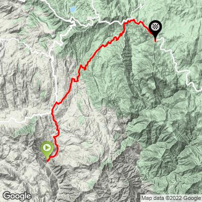
FULL CLIMB STATS
INTRO
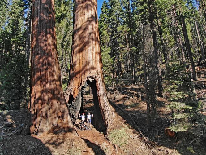
Whitaker Forest is much more than a challenging climb - it is an exceptional experience. The climb is ranked the 21st most difficult bike climb in the US. In addition to tackling another very hard climb, with this one, you get some experiences that range from unique, to exceptional, to one-of-a-kind, including the only Ride-Through-Tree we have ever come across on a climb.
Average grade is 5.2% (6.9% climb only). 46% of the climb is at 5-10% grade and 10% is at 10-15%. The steepest quarter mile is 24% and steepest mile 12.1%.
See more details and tools regarding this climb's grade via the “Profile Tool” button.
Roadway: The majority of the paved portion of this climb is good to excellent. There are some sections of the paved climb that are a bit rough and in low-good condition. There are 4.5 miles of dirt from miles 16.5 to 21 that are easily manageable on road bike and are my favorite part of the climb - epic!!
Traffic: Negligible. I encountered a vehicle on the dirt section my first trip up Whitaker (a rancher looking for stray cows - she directed me to the ride-through tree - she rides her horse through it). There is never more than minimal traffic anywhere on the route.
Parking: Anywhere near the start of the climb - there are many places to park along the side of the road. We parked at the start of the climb here: Map; Street View.
Gear: If you have concerns about the 4.5 miles of dirt, bring a gravel bike. I would recommend at least 28mm for the climb, but I did it the first of two times on 25mm.
Provisions: There are no stores along the route. There is the Baker Mountain House café at the junction of J21 and Highway 245 at mile 5.2.
Before heading out on any cycling adventure check out our Things to Bring on a Cycling Trip and use our interactive check list to ensure you don't forget anything.
We stayed in Visalia the two trips we took to this area to do the Kings Canyon/Sequoia NP climbs. The area also has options for vacation rentals. See the PJAMM climb pages for Sequoia National Park and Kings Canyon National Park for more information on climbs in this area.
Ride through tree - I missed this both times I did the ride and had to ride back to see and do it. The tree is on you left 18.8 miles from the climb start and 1.2 miles before you reach Hwy 198 - Route Map. Also consider riding another 20 miles to view General Sherman Tree (largest tree by volume in the world) - Route Map; Google Map + Reviews - whether by car of bike, we do recommend you visit this spectacular natural wonder.
ROUTE MAP
MEMBER RATING
CURRENT WEATHER
PJAMM TRIPS ADVENTURE STARTER BUNDLES
Check out PJAMM Adventure's prepackaged (self-guided) cycling trips. They will help you plan, document and conquer your next adventure.
NEARBY CLIMBS (0) RADIAL PROXIMITY
FROM No Climbs Found
MEMBER REVIEWS & COMMENTS
Let us know what you thought of this climb. Signup for our FREE membership to write a review or post a comment.
Already have an account?
LOG IN HERE
bike-ra
It’s hard to call Whitaker Forest Rd. a “road†anymore since it looks like it’s been left to return to nature. The last 5mi. before the General’s Hwy has degraded greatly since PJAMM’s description above and even further since the below 10/22 review due to the ‘23 winter/spring snow/runoff/rains. The road over Eshom Creek is washed out (we rock hopped to cross it), and there’s several partial road washouts along the way & many deep ravines across the road that a 4WD jeep might not survive. On the better sections the surface is mostly loose gravel & dirt over a rutted surface (level 3-4 in gravel road parlance). I rode maybe 20% of this 5mi. on 30mm tubeless road tires (my wife walked the whole way due to her tubed 28mm tires). Gravel bike tires would provide more traction on the better sections but won’t help much with crossing the many chasms. Otherwise the scenery is stunning but it should no longer be considered a “bike climbâ€!
whitworks1
Utterly unique ride. The trees are beyond description or really even comprehension.
MULTIPLE CAUTIONS!
This ride really is for a gravel or cx bike or mtb. 1st section of this route is paved, lane and a half wide, many dangerous blind curves and no shoulder. 2nd section same, but with lots of traffic. 3d section on WF raod is paved, but bumpy AF. 4th section from Eshom Campground to KC boundary, the surface is NOT paved. Big rocks, roots, chunders, all churned up by CDF trucks doing controlled burns. 5th section from KC boundary to park central road also not paved, but much smoother. 6th section to Baldy trailhead, smooth as silk. You can squeak by on a robust road tire uphill, but downhill would knock your molars out. And you'd probably flat. Oh, and at the top it says this road is closed, but not at the bottom so...


