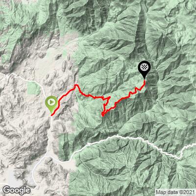
Bear Creek Road Bike Climb - PJAMM Cycling

11.4
FIETS
16 mi
DISTANCE
5,477 ft
GAINED
6.3 %
AVG. GRADE

FULL CLIMB STATS

INTRO

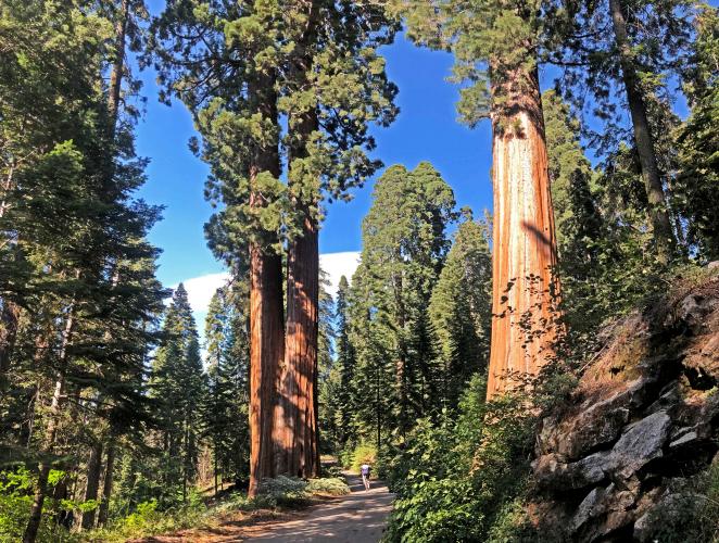
This is one of the greatest bike climbing experiences in California. We end this climb in Sequoia National Forest among giant sequoia redwood trees. This climb rivals the Whitaker Forest climb for an awe-inspiring ride through a giant sequoia redwood forest.
"Bear Creek Road is a big climb which shares its end with Balch Park. The shallow start gradually gets steeper as you head up a drainage. Just over 3 miles in you cross a creek and immediately hit steeper grade. In fact these next 3 miles are the crux stretch as they average just under 8% grade. The slope then eases as you are now within thick woods. At mile 17 turn right for the final steep stretch to Sequoias and pavement's end..." (This quote is presented with the approval of John Summerson, from his book, The Complete Guide to Climbing (by Bike) in California, pg. 160.)
The average grade of this climb is 6.1% (6.9% for climb only).  33% of the climb is at 0-5% grade, 41% is at 5-10%, 14% is at 10-15%, 3.5% is at 15-20%, and a fraction at 20%+.    The steepest quarter-mile is 18.7% and steepest mile 10.9%.

See more details and tools regarding this climb's grade via the “Profile Tool” button.
Roadway:  This is a narrow two lane road without a center stripe most of the climb

Traffic:  Minimal.

Parking:  At the start of the climb.  MapStreet View
Provisions:  There are no spots for water or food on this route. The nearest food and beverages are in Springville four miles south - Map.
Before heading out on any cycling adventure check out our Things to Bring on a Cycling Trip and use our interactive check list to ensure you don't forget anything.
This is one of several amazing bike climbs in the area.  See PJAMM's climb pages for Kings Canyon National Park and Sequoia National Park.  For other climbs in the area use the “Routes in Area” button on the menu bar to see other bike climbs in this area.

ROUTE MAP

MEMBER RATING

Difficulty: Strenuous
1
Road
5
Traffic
5
Scenery

CURRENT WEATHER

PJAMM TRIPS ADVENTURE STARTER BUNDLES

Check out PJAMM Adventure's prepackaged (self-guided) cycling trips. They will help you plan, document and conquer your next adventure.
ALL TRIPS
Browse all of our prepackaged trips and find your next adventure!
Sequoia and Kings Canyon
United States (CA)
15 ROUTES
11 POIs
ROUTE STATS (TOTAL)
281
mi
DISTANCE
77,122
ft
ELEV. GAIN

NEARBY CLIMBS (0) RADIAL PROXIMITY

FROM
No Climbs Found

MEMBER REVIEWS & COMMENTS

Let us know what you thought of this climb. Signup for our FREE membership to write a review or post a comment.
Already have an account?

Jul 5, 2021
difficulty: Strenuous
scenery: 5
traffic: 5
road: 1
Jul 5, 2021
scenery: 5
traffic: 5
road: 1
Beautiful climb once you get a little over halfway! There is parking right at the beginning on either side of the road. Once you get past the one lane bridge, the climb gets much steeper and stays that way for about a mile. Otherwise, the climb is just punches up to 15 percent and then flattens afterwards. The road to the right at the top was closed when I was there, but Balch Park is also pretty. The road condition is pretty horrible, tons of potholes and cracked pavement. I wouldn't recommend descending it if you can help it. Balch Park rd which is the normal route for cars is currently closed due to a fire so this is the only way up and down for cars (as of 7/5/2021). This makes for more traffic, but there was very little traffic when I did it (maybe 20 cars?). Start early as it can get very hot
ROUTE MAP
PROFILE TOOL
Route Data
S.G. (%)
hide
Segment Data
hide

Climb Profile Not Found
CLIMB SUMMARY


Cycling Bear Creek Road: One of the most scenic bike climbs in California.

Along with Highway 198 and Whitaker Forest, Bear Creek Road is among the greatest bike climbs

involving California’s Giant Sequoias.

Photo:  The lower half of the photo is the Bear Creek Road section of Giant Sequoias.

This a simply a remarkable climb and experience.  Now, truth be told, the first 6 ½ miles of this stout 16 mile climb are nothing much to speak of.  However, keep the faith because we promise you that this will be a memorable climb if you stick with it all the way to the top, off the “main” road, along a narrow dirt road through giant Sequoia Redwood Trees -- AWESOME views available nowhere else on earth.

Bear Creek Road is billed as a logging road, and rightly so.  Our climb, and the road, begins at the intersection of Balch Park Road and Bear Creek Roads.


Start of climb, sign says “LOG TRUCK TRAFFIC AHEAD”...

. . . and they aren’t kidding!

At about Mile 4 of this climb, we enter Sequoia National Forest.  The last third of the climb is squarely within thickly forested surroundings rivaling those of Humboldt and Del Norte counties in Northern California.


Enter Sequoia National Forest at Mile 4

Established 1908 by President Teddy Roosevelt,

1,193,315 acres.

We cannot emphasize enough how incredible the last few miles of this ride are, giving us a glimpse into the past through the powerful,mighty, and ancient Giant Sequoias (see slideshow).  The alpine setting begins around Mile 15 (we have sage, chaparral, oak, and grasslands from the beginning, giving way to Pine, Redwood and finally, Sequoia as we climb higher into the Sequoia National Forest).

Our first Sequoia at Mile 14 (photo upper left), the final two miles are heaven!

Finish - photo bottom left.  

Important Navigation Note:  Bear Creek Road becomes Balch Park Road at mile 14.8 and you must take a very sharp turn to the right to continue on Bear Creek Road (video beginning at 50 second mark shows this turn) toward Shake Camp, Pack Station, and Tule River (there is a sign, facing away from us on the ascent, with these details); we have climbed this route twice and missed that turn twice!  

Bicycling  Bear Creek Road - fork in the road and sign -

Turn here at Mile 14.7.

Stay left on the pavement (becomes Balch Creek Rd) to Balch Creek Campground, or . . .

. . . bear right to finish the climb on 1.3 more miles up Bear Creek Road

After turning right onto Bear Creek at its junction with Balch Park Road, we climb another 1.2 miles at 5.8% grade through ​​a breathtakingly spectacular Redwood/Sequoia forest (slideshow).  This area is in the heart of Balch Park which offers camping and many recreational activities.  About a quarter mile after turning right be alert for the Giant Sequoia named Oliver Twist -- it is MAGNIFICENT!

Oliver Twist.

Cycling Bear Creek Road - PJAMM cyclist at Oliver Twist Giant Sequoia tree

 Bike climb  Bear Creek Road - Oliver Twist giant sequoia sign

After completing the final 1.2 miles of the climb, retrace your steps to Bear Creek/Balch Park road, turn right and travel another 0.2 miles to Balch Park Public Camp and enjoy the beautiful pond, hollow tree, and the unattended but very informative museum providing the history of Balch Park and turn of the century (19th, that is) logging photos and history (slideshow).


Pond near the park.

Traffic and Roadway Surface Report:  The roadway surface, other than the first three miles, is poor, rutted, pot-holed, and with plenty of loose gravel, all combining to create a rough descent.  There is very little traffic on the roadway and we experience a very quiet and peaceful ascent for 12 miles after entering the national forest.

There is plenty of lodging in Porterville, California, as well as camping in either Sequoia and/or Kings Canyon National Parks to the north.  

Kings Canyon and Sequoia National Parks

Photo - from upper left clockwise:

Bear Creek; Mineral King; Hwy 198; Whitaker Forest; 


That’s a wrap!

Access to full Climb Summary requires a PJAMM Cycling PRO Membership!

It takes less than a minute to sign up & with your PRO membership you can:
  • Rate climbs, post comments and share your experiences on any of our climb pages
  • Create bucket lists of climbs & mark the dates you complete them
  • Weather data for all climbs - Start & Finish
  • Upload photos to your member page to customize your PJAMM Cycling experience
  • Utilize all of our interactive tools - Profile & Routes in Area
  • Download climb route .gpx files
LEARN MORE
SIGN UP

Already have an account? LOG IN HERE