IRONMAN Kona World Championship Triathlon - PJAMM Cycling

BIKE STATS:
0 mi
DISTANCE
0 ft
PEAK ELEV.
0 ft
ELEV. GAINED
0 %
STEEPEST ¼ mi

FULL COURSE STATS

INTRO

The most famous triathlon in the world, the one that changed the sport forever, and continues to define it each year.  This is truly the pinnacle of triathlon. 

The Iron Man Triathlon was created when Judy and John Collins moved to Hawaii and wanted to create a triathlon race designed for true extreme endurance athletes. The couple had fallen in love with the young sport while living in Southern California, and had competed in what is believed to be the first ever modern swim/bike/run triathlon in San Diego in 1974.  The idea for the course came from adding together the 3 toughest events on the island: the Waikiki Roughwater Swim, the Around-Oahu Bike Race, and the Honolulu Marathon. 

The World Championship is by qualification only: the only way to earn a spot is by winning or making the podium in your age group/category. 
Complete Race Schedule

Parking:
The best places to stay on the island for this race are in Kona, Waikoloa Beach, or Waikoloa Village. On race morning, there's parking in this General Area. Note that Palani Road will be closed for the course so take Henry St to Alahou St.

Historical Weather:
Usually taking place in October, this race is notoriously humid, with highs anywhere in the 80s. Check the PJAMM Cycling Weather Tool for both current and historic weather data.


Explore and compare other triathlons and Ironman races on our Triathlon Homepage
Information Not Available

If you have any information regarding this triathlon, we'd like to hear from you. Click the CONTRIBUTE button to share your thoughts with us.
We're on the Big Island at least every other year, but for two main reasons: 1) Mauna Kea, and 2) Mauna Loa.  Don't forget to sample some of the world famous Kona grown coffee, believed by many to be the best coffee in the world due to its fertile volcanic soil and perfect growing conditions. 

Good Hotels:

Good Restaurants:

Good Brews (☕️+🍻):

COURSE MAP

CURRENT WEATHER

PJAMM TRIPS ADVENTURE STARTER BUNDLES

Check out PJAMM Adventure's prepackaged (self-guided) cycling trips. They will help you plan, document and conquer your next adventure.
ALL TRIPS
Browse all of our prepackaged trips and find your next adventure!
140.6 World Championship - Kona
United States (HI)
7 ROUTES
24 POIs
ROUTE STATS (TOTAL)
141.1
mi
DISTANCE
5,420
ft
ELEV. GAIN

NEARBY BIKE CLIMBS (0) RADIAL PROXIMITY

FROM
No Climbs Found

MEMBER COMMENTS

Let us know your thoughts about this triathlon. Signup for our FREE membership to post a comment or question.
Already have an account?
ROUTE MAP
PROFILE TOOL
Route Data
S.G. (%)
hide
Segment Data
hide

Climb Profile Not Found
RACE REVIEW

IRONMAN Kona Bike Course Analysis
The Queen K Highway

View from mile 79

Overall Surface Quality:

Excellent. Even the shoulder of the Queen K is a dream to ride on, and most of the roads on the big island are in surprisingly great shape. Islanders drive fast, so be careful during warmup rides.

Bike Course Records

Male: Cameron Wurf, 2018 (4:09:06);  https://www.strava.com/activities/1903697525 

Female: Daniela Ryf, 2018 (4:26:27)

Strava Segment:

https://www.strava.com/segments/5806453 

Significant Ascents:

Like the entire big island, the bike course is very hilly. Even though the Queen K appears flat while riding, the course will feel like a constant up and down with 24 miles of false flat  (1%-3%).

Climb out of Kona (@ mi 6.7)

  • Short but steep, peaks at over 8% briefly

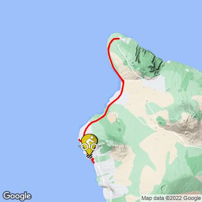
Climb into the Hawi turnaround (@ mi 52.7)

  • The most intimidating bump on the profile isn’t anything to be afraid of when you properly stretch it out. The biggest incline on the course gains over 500 feet and reaches the highest part of the course, but is actually nearly all false flat, rarely breaking a 3% grade.

Climb to Queen K - Kawaihae Rd intersection (@ mi 77.7)

  • The steepest climb on the course. Hits 6% twice, peaks at 7.2%.

Climb to Puako Beach Dr (@ mi 81.7)

  • This could be our favorite climb on the course… Well, ok, not really a climb. But at the top of this hill is the famous Hot Malasadas Truck, or a traditional Hawaiian donut, cooked fresh to order. You probably won’t want to pause your race for one of these, but if you’re having an especially bad ride... 🍩

Rise to Kīholo scenic overlook (@ mi 93)

  • Last significant incline on the course, a 2.1 mile false flat. 232 feet gained in total.

An even bigger factor than the climbs are the notorious winds.  Nearly all of this climb is completely exposed, and crosswinds are so much a factor that disc wheels are not allowed.

Click here to view a full interactive profile of the 112 mile course.


Turn by Turn Course Recon:

*Turn angle is measured by the sharpest corner angle throughout the entire turn*

Click thumbnail for example (66˚ turn)

Turn 1:

87˚ Right turn;  Mile 0.6

Entrance gradient (preceding .1 mile): -0.4%

Exit gradient (next .1 mile): 0.4%        

Google Street View


Turn 2:

56˚ Right turn;  Mile 1.2

Entrance gradient (preceding .1 mile): 3.7%

Exit gradient (next .1 mile): 1.4%        

Google Street View


Turn 3:

40˚ Right turn;  Mile 1.8

Entrance gradient (preceding .1 mile): -2.5%

Exit gradient (next .1 mile): -5%        

Google Street View


Turn 4:

62˚ left turn;  Mile 2.1

Entrance gradient (preceding .1 mile): -4.9%

Exit gradient (next .1 mile): -1%        

Google Street View


Turn 5:

180˚ U-turn;  Mile 4.4

Entrance gradient (preceding .1 mile): 2.1%

Exit gradient (next .1 mile): -2.1%        

Google Street View


Turn 6:

75˚ Right turn;  Mile 6.7

Entrance gradient (preceding .1 mile): 1%

Exit gradient (next .1 mile): 4.9%        

Google Street View


Turn 7:

55˚ left turn;  Mile 7.1

Entrance gradient (preceding .1 mile): 1.7%

Exit gradient (next .1 mile): -0.4%        

  • Short 7% climb leads precedes turn

Google Street View


Turn 8:

71˚ left turn;  Mile 40

Entrance gradient (preceding .1 mile): 2.8%

Exit gradient (next .1 mile): -5.2%        

Google Street View


Turn 9:

180˚ U-turn;  Mile 59

Entrance gradient (preceding .1 mile): 2.2%

Exit gradient (next .1 mile): -2.2%

Google Street View


Turn 10:

50˚ Right turn;  Mile 78.6

Entrance gradient (preceding .1 mile): 5.2%

Exit gradient (next .1 mile): -2.8%

  • Biggest climb of the course precedes turn

Google Street View


Turn 11:

52˚ Right turn;  Mile 111

Entrance gradient (preceding .1 mile): -1.4%

Exit gradient (next .1 mile): -3.7%        

Google Street View


Turn 12:

88˚ Right turn;  Mile 111.5

Entrance gradient (preceding .1 mile): 0.4%

Exit gradient (next .1 mile): -0.4%        

Google Street View


Turn 13:

71˚ Right turn;  Mile 40

Entrance gradient (preceding .1 mile): -1%

Exit gradient (next .1 mile): -3.2%        

Google Street View


Transition Layout:

Obstacles and Other Notes:

  • Extremely strong crosswinds most years. Check the PJAMM Cycling Weather Tool for up to date conditions along the course.
  • Be prepared for high humidity

Current / Historical Weather Patterns

Full Interactive Bike Course Profile

Link to main race site:

https://www.ironman.com/im-world-championship-2022 

Notice an error,  have a suggestion, or an update to this information? Contact us at samlyons@pjammcycling.com!