
BIKE STATS:
0 mi
DISTANCE
0 ft
PEAK ELEV.
0 ft
ELEV. GAINED
0 %
STEEPEST ¼ mi
FULL COURSE STATS
INTRO
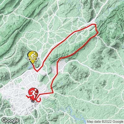
This course contains the third hardest climb in any Ironman race in the world: the 4.8 mile, +1600 foot Route 43 North to Blue Ridge Parkway. Furthermore, right out of transition you'll be greeted by half a mile of +6% grades. This is an extremely popular race and tends to sell out quickly every year.
70.3 Virginia's Blue Ridge is a half-Ironman triathlon located in Roanoke, VA, USA. The swim is 1.2 mi, bike is 56 mi, and the run is 13.1 mi. Use the profile tool, route maps, weather forecast, and other tools on this page to more efficiently and effectively train for your race.
Also, find and compare other Ironman and 70.3 races on our Triathlon Homepage.
If course information is missing or outdated, please let us know at info@pjammcycling.com
Full Event Schedule
Parking:
There is no parking at Carvins Cove Reservoir/T1, instead park in one of these 4 lots and take the athlete shuttle (running from 3:15am to 5:00am)
- Carilion Clinic Riverside Parking Garage
- Carilion Clinic Crystal Springs Garage
- Carilion Clinic Riverwalk Parking Deck
- Carilion Clinic Center for Simulatio
Spectators will stay at Ironman Village for a live-stream watch party!
Historical Weather:
Can be very rainy and usually is humid. Check the PJAMM Cycling Weather Tool for current and historic weather data.
Local Tri Shops:
Local Public Pools:
- Virginia Gators Swim Club (indoor)
- Read Mountain Swim Club (outdoor)
Popular open water swim areas:
Other than for the race, it's illegal to swim in the Carvins Cove Recreation Area** (race venue)
Bike:
- The bike course is mountanious with 4,081 ft of elevation gain.
- 10.2 mi of the course is an uphill false flat (1 to 3%)
- 10 mi of uphill climbing (+3%)
- 21.3 mi are downhill (< -1%)
- 15.4 mi are flat (-1 to 1%)
Major climb:
@ Mile 23: Route 43 North to Blue Ridge Parkway (4.8 miles, 6.4%, 1640 ft climbed)
Run:
The run is flat with 220 ft of elevation gain and 234 ft of elevation descent.
- 1.2 mi of the course is an uphill false flat (1 to 3%)
- 0.1 mi of uphill climbing (+3%)
- 1.3 mi are downhill (< -1%)
- 10.5 mi are flat (-1 to 1%)
The race reaches a peak of 2,500 ft above sea level.
Check out Mill Mountain right in downtown Roanoke for a good race week warmup climb. (1.7 mi @ 8.7%)
Good Hotels:
Good Restaurants:
Good Brews (☕ï¸+ðŸº):
COURSE MAP
CURRENT WEATHER
PJAMM TRIPS ADVENTURE STARTER BUNDLES
Check out PJAMM Adventure's prepackaged (self-guided) cycling trips. They will help you plan, document and conquer your next adventure.
NEARBY BIKE CLIMBS (0) RADIAL PROXIMITY
FROM No Climbs Found
MEMBER COMMENTS
Let us know your thoughts about this triathlon. Signup for our FREE membership to post a comment or question.
Already have an account?
LOG IN HERE


