70.3 St. George Triathlon - PJAMM Cycling

BIKE STATS:
0 mi
DISTANCE
0 ft
PEAK ELEV.
0 ft
ELEV. GAINED
0 %
STEEPEST ¼ mi

FULL COURSE STATS

INTRO

St. George is generally regarded by Ironman pros as the hardest 70.3 course, but also the most fun. This beautiful course is extremely popular and sells out every year. This year it is home to the 70.3 World Championships and open by qualification only.

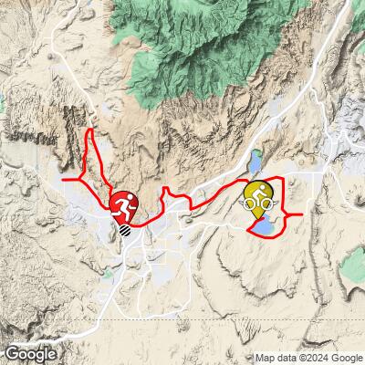
This course is one of the few Ironmans that include a PJAMM ranked climb, Snow Canyon (mile 44;  2.8 miles @ 5.7% avg grade). The descent down Hwy 78 to T2 will be fast, breaking a -7% grade three times.

Explore and compare other triathlons and Ironman races on our Triathlon Homepage.
Complete Race Schedule

Parking:
Shuttles will transport the athletes from Town Square Park to T1 (Sand Hollow Reservoir) at 4:00AM.  Street parking and open lots are all around the area for athletes. Spectators who want to watch the swim can park along the south side of the reservoir ( a 1.3 mile walk from swim launch)

Historical Weather:
Late October is debatably the best time of year to visit southern Utah in general. Sunny skies, temperatures in the mid 70s, and very low humidity is the norm. Since you'll be racing in a desert, you'll want to err on the cautious side with your hydration program.  Check the PJAMM Cycling Weather Tool for both current and historic weather data.

Information Not Available

If you have any information regarding this triathlon, we'd like to hear from you. Click the CONTRIBUTE button to share your thoughts with us.

We all know about southern Utah's incredible National Parks in the St George area, not to mention the Grand Canyon an easy 2.5 hour drive south, but cycling in these parks is an incredible way to experience them. And you'll already have your bike...  
Check out our pages on cycling Utah's National Parks for ideas: 
Bryce Canyon National Park
Other nearby attractions within a couple hours include Horseshoe Bend, Antelope Canyon, and the Las Vegas Strip. 

Good Hotels:

Good Restaurants:

Good Brews (☕️+🍺):

COURSE MAP

CURRENT WEATHER

PJAMM TRIPS ADVENTURE STARTER BUNDLES

Check out PJAMM Adventure's prepackaged (self-guided) cycling trips. They will help you plan, document and conquer your next adventure.
ALL TRIPS
Browse all of our prepackaged trips and find your next adventure!
70.3 St. George
United States (NV,UT)
4 ROUTES
20 POIs
ROUTE STATS (TOTAL)
69.8
mi
DISTANCE
4,616
ft
ELEV. GAIN

NEARBY BIKE CLIMBS (0) RADIAL PROXIMITY

FROM
No Climbs Found

MEMBER COMMENTS

Let us know your thoughts about this triathlon. Signup for our FREE membership to post a comment or question.
Already have an account?
ROUTE MAP
WEATHERView Tutorial

Use of the Weather Tool requires a PJAMM Cycling FREE Membership!

It takes less than a minute to sign up & with your FREE membership you can:
  • Rate climbs, post comments and share your experiences on any of our climb pages
  • Create bucket lists of climbs & mark the dates you complete them
  • Weather data for all climbs - Start Only
    (Weather at climb Finish requires a PRO Membership)
Take a video tour:
LEARN MORE
SIGN UP

Already have an account? LOG IN HERE

PROFILE TOOL
Route Data
S.G. (%)
hide
Segment Data
hide

Climb Profile Not Found
RACE REVIEW

70.3 St. George Bike Course Analysis

Overall Surface Quality:

Good; much of the course was re-paved over the past 2 years.

Last year’s fastest times:

Male: Gustav Iden, 1:58:59 / 28.2 mph

Female: Lucy Charles, 2:14:59 / 24.9 mph

Strava Activity of last year’s Champion (or runner up):

Male: https://www.strava.com/activities/5981890643 

Female: https://www.strava.com/activities/5986646049 

Strava Segment:

https://www.strava.com/segments/28263295 

Transition Layout:

T1:

T2:

                                Course Recon                                

Major Ascents:

Snow Canyon (@ mi 44)    -    4.5 mi,  4.4% grade, 1038ft gained, 1.6 fiets

(steepest section pictured)


Southern Parkway Climb (@ mi 3.7)    -    .9 mi,  5.3% grade,  238ft gained

(complete hill pictured)


W State Street Climb (@ mi 15.8)    -    Breaks 5% twice


Washington Parkway Climb (@ mi 22.5)    -   peaks at just under 8%

(complete hill pictured)


Red Hills Parkway Climb (@ mi 33.7)    -    peaks at just under 8%

Turn by Turn:

Turn 1:

90˚ Left turn;  Transition to Sand Hollow Road;  Mile 0.5:

Entrance gradient (preceding .1 mile): -0.1%

Exit gradient (next .1 mile): 1%        

Street View        


Turn 2:

90˚ Left turn; Mile 1.4

Entrance gradient (preceding .1 mile): 3.1%

Exit gradient (next .1 mile): -1.5%                                                

Street View


Turn 3:

90˚ Right turn;  Mile 6

Entrance gradient (preceding .1 mile): 3.4%

Exit gradient (next .1 mile): -1.9%                                                

No Street Views


Turn 4:

180˚ U-turn;  Mile 7.7

Entrance gradient (preceding .1 mile): 0.1%

Exit gradient (next .1 mile): -0.1%                                                

Street View


Turn 5:

90˚ Right turn; Mile 9.5

Entrance gradient (preceding .1 mile): 3.4%

Exit gradient (next .1 mile): -4.3%                                                

No Street Views


Turn 6:

90˚ Left Turn; Mile 12.7

Entrance gradient (preceding .1 mile): -4.1%

Exit gradient (next .1 mile): -5.7%                                                

No Street Views


Turn 7:

90˚ Left turn;  Mile 18.2

Entrance gradient (preceding .1 mile): -1%

Exit gradient (next .1 mile): -3.5%                

Street View


Turn 8:

90˚ right turn;  Mile 21.8

Entrance gradient (preceding .1 mile): 2.1%

Exit gradient (next .1 mile): 1.7%                

Street View


Turn 9:

100˚ left turn;  Mile 23.2

Entrance gradient (preceding .1 mile): 0%

Exit gradient (next .1 mile): -5.4%                

Street View out of date


Turn 10:

80˚ left turn;  Mile 26.9

Entrance gradient (preceding .1 mile): 2.9%

Exit gradient (next .1 mile): -0.9%                

Street View out of date


Turn 11:

90˚  left turn;  Mile 29.3

Entrance gradient (preceding .1 mile): -5.4%

Exit gradient (next .1 mile): -3.6%                

 No Street View


Turn 12:

90˚  left turn;  Mile 31.5

Entrance gradient (preceding .1 mile): -1%

Exit gradient (next .1 mile): 0.1%                

Street View


Turn 13:

120˚  left turn;  Mile 41.3

Entrance gradient (preceding .1 mile): 0%

Exit gradient (next .1 mile): 1.9%

Street View


Turn 14:

100˚  left turn;  Mile 46.3

Entrance gradient (preceding .1 mile): 4.9%

Exit gradient (next .1 mile): -2.8%                

Street View


Turn 15:

45˚  left turn;  Mile xx

Entrance gradient (preceding .1 mile): -6%

Exit gradient (next .1 mile): -4.7%                

Street View


Turn 16:

90˚  left turn;  Mile xx

Entrance gradient (preceding .1 mile): -1.6%

Exit gradient (next .1 mile): 0%                

Street View


Obstacles and Other Notes:

  • Two transitions/point to point course
  • Closeup of crossover:

Current / Historical Weather Patterns

Full Interactive Bike Course Profile

Link to main race site: https://www.ironman.com/im703-world-championship 

Notice an error,  have a suggestion, or an update to this information? Contact us at samlyons@pjammcycling.com!