70.3 Muskoka
Bike Course Recon
Overall Surface Quality:
Average - well paved and smooth in most sections, but some of course is weathered rural roads
Significant Ascents:
This bike course is characterized by one thing and only one thing: ROLLERS. With over 1100 meters climbed but only a range in 110m of elevation, this is the rolliest 70.3 bike in the world. If you’re not built for a constant up and down, you’re going to have a… fun time on the bike.
You can tell by just looking, this profile looks like the blade of a hacksaw:
![]()
Only 1/3 of the 90km course is flat (falls within the range of -1% to 1% grade). These hills are very short, but can get extremely steep, just look at hill #1. Since there are only a couple turns on the whole course (out and back) we’ll mainly cover the hills here, and since there are more than you can keep track of, we’ve made a table with the locations of the important ones for you to print out and tape to your top tube or stem (see at bottom).
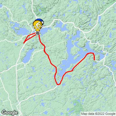
Snapshot of profile and Google Streetview below:
1) @ km 1.0 Length: 200m, 21m gained, 19.6% peak gradient
![]()
![]()
2) @ km 2.9 Length: 200m, 12m gained, 10.9% peak gradient
![]()
![]()
3) @ km 5.4 Length: 950m, 36m gained, 7.4% peak gradient
![]()
![]()
4) @ km 7.2 Length: 770m, 46m gained, 14.6% peak gradient
![]()
![]()
5) @ km 8.2 Length: 200m, 10m gained, 7.2% peak gradient
![]()
![]()
6) @ km 10.8 Length: 750m, 49m gained, 13.0% peak gradient
![]()
![]()
7) @ km 15 Length: 350m, 18m gained, 9.9% peak gradient
![]()
![]()
8) @ km 17.4 Length: 180m, 10m gained, 9.1% peak gradient
![]()
![]()
9) @ km 18.0 Length: 600m, 20m gained, 9.1% peak gradient
![]()
![]()
10) @ km 19.6 Length: 240m, 17m gained, 10.3% peak gradient
![]()
![]()
11) @ km 23.5 Length: 250m, 14m gained, 9.9% peak gradient
![]()
![]()
12) @ km 40.2 Length: 550m, 19m gained, 7.1% peak gradient
![]()
![]()
13) @ km 42.8 Length: 950m, 27m gained, 7% peak gradient
![]()
![]()
14) @ km 44.5 Length: 520m, 22m gained, 6.3% peak gradient
![]()
![]()
15) @ km 46 Length: 370m, 16m gained, 7.4% peak gradient
![]()
![]()
16) @ km 50 Length: 500m, 19m gained, 7.1% peak gradient
![]()
![]()
17) @ km 51.5 Length: 760m, 23m gained, 7% peak gradient
![]()
![]()
18) @ km 53.3 Length: 580m, 26m gained, 8.3% peak gradient
![]()
![]()
19) @ km 63.1 Length: 280m, 12m gained, 7.3% peak gradient
![]()
![]()
20) @ km 66 Length: 330m, 14m gained, 7% peak gradient
![]()
![]()
21) @ km 69.3 Length: 850m, 38m gained, 8.4% peak gradient
![]()
![]()
22) @ km 71 Length: 175m, 9m gained, 10% peak gradient
![]()
![]()
23) @ km 72.2 Length: 250m, 18m gained, 12.5% peak gradient
![]()
![]()
24) @ km 72.6 Length: 340m, 24m gained, 11.3% peak gradient
![]()
![]()
25) @ km 73.9 Length: 800m, 44m gained, 11.7% peak gradient
![]()
![]()
26) @ km 76.7 Length: 600m, 17m gained, 7.3% peak gradient
![]()
![]()
27) @ km 83.8 Length: 360m, 18m gained, 10.8% peak gradient
![]()
![]()
28) @ km 88.2 Length: 480m, 18m gained, 8.3% peak gradient
![]()
![]()
29) @ km 88.9 Length: 490m, 20m gained, 10% peak gradient
![]()
![]()
Click here to view a full interactive profile of the 56 mile course.
Now of course there’s no way for you to remember all of those, let alone when you’re 65km into the course and in excruciating pain, so here’s a table of the major hills to print out and tape to your top tube:
![]()
(numbers are rounded up)
General Map of Transition
Obstacles and Other Notes:
- Due to the amount of climbing/descending, it’s not uncommon to see people choose to ride road bikes with drop bars + clip on aero bars for this triathlon.
Current / Historical Weather Patterns
Full Interactive Bike Course Profile
Link to main race site:
https://www.ironman.com/im-canada?_ga=2.23307258.1525243513.1652043783-1560196912.1650922734
Notice an error, have a suggestion, or an update to this information? Contact us at samlyons@pjammcycling.com!
![]()