INTRO
If you have any information regarding this triathlon, we'd like to hear from you. Click the CONTRIBUTE button to share your thoughts with us.
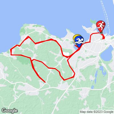
COURSE MAP


If you have any information regarding this triathlon, we'd like to hear from you. Click the CONTRIBUTE button to share your thoughts with us.

IRONMAN Tallinn Estonia
Bike Course Recon
Overall Surface Quality:
Average - well paved, but most of course is weathered rural roads
Strava workout from last year’s race:
https://www.strava.com/activities/5753690993 (slightly different course)
Strava Segment:
https://www.strava.com/segments/29468776
Significant Ascents:
The 2.5 lap bike course is fairly straightforward and hilly. The gradient rarely breaks 4% and when it does, it's not for very long; the longest hill is less than 1.5 km.
Hill from Harku Järv (@ km 3 and 91) 1km, 25m gained, 7.4% peak gradient
Hill to Türisalu Cliff (@ km 26 and 114) 1.3km, 25m gained, 7.8% peak gradient
Click here to view a full interactive profile of the 112 mile course.
Turn By Turn
*Turn angle is measured by the sharpest corner angle throughout the entire turn*
Click thumbnail for example (66˚ turn)
There are only a few sharp turns along the entire course that you may enter at high speeds:
@ km 19.5 and 74
90˚ left turn:
Entrance gradient (preceding 100 meters): 0%
Exit gradient (next 100 meters): 0%
@ km 45 and 133
180˚ turn:
Entrance gradient (preceding 100 meters): 0%
Exit gradient (next 100 meters): 0%
Transition Layout
Satellite Image of T1:
Obstacles and Other Notes:
Current / Historical Weather Patterns
Full Interactive Bike Course Profile
Link to main race site:
https://ironman.com/im-tallinn?_ga=2.205210192.1525243513.1652043783-1560196912.1650922734
Notice an error, have a suggestion, or an update to this information? Contact us at samlyons@pjammcycling.com!