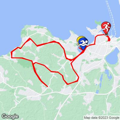
IRONMAN Tallinn Estonia
Bike Course Recon
Overall Surface Quality:
Average - well paved, but most of course is weathered rural roads
Strava workout from last year’s race:
https://www.strava.com/activities/5753690993 (slightly different course)
Strava Segment:
https://www.strava.com/segments/29468776
Significant Ascents:
The 2.5 lap bike course is fairly straightforward and hilly. The gradient rarely breaks 4% and when it does, it's not for very long; the longest hill is less than 1.5 km.
Hill from Harku Järv (@ km 3 and 91) 1km, 25m gained, 7.4% peak gradient
![]()
Hill to Türisalu Cliff (@ km 26 and 114) 1.3km, 25m gained, 7.8% peak gradient
![]()
Click here to view a full interactive profile of the 112 mile course.
Turn By Turn
*Turn angle is measured by the sharpest corner angle throughout the entire turn*
Click thumbnail for example (66˚ turn)
![]()
There are only a few sharp turns along the entire course that you may enter at high speeds:
@ km 19.5 and 74
90˚ left turn:
Entrance gradient (preceding 100 meters): 0%
Exit gradient (next 100 meters): 0%
![]()
Google Street View
@ km 45 and 133
180˚ turn:
Entrance gradient (preceding 100 meters): 0%
Exit gradient (next 100 meters): 0%
![]()
Google Street View
Transition Layout
Satellite Image of T1:
![]()
Obstacles and Other Notes:
Current / Historical Weather Patterns
Full Interactive Bike Course Profile
Link to main race site:
https://ironman.com/im-tallinn?_ga=2.205210192.1525243513.1652043783-1560196912.1650922734
Notice an error, have a suggestion, or an update to this information? Contact us at samlyons@pjammcycling.com!
![]()

