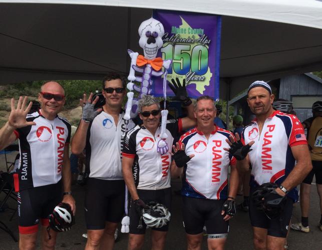
PJAMM 2015
Death Ride: 5 for 5 - YEAH!

PJAMM’s Profile Tool
Click on “Profile Tool” just below “Full Summary” for interactive data.
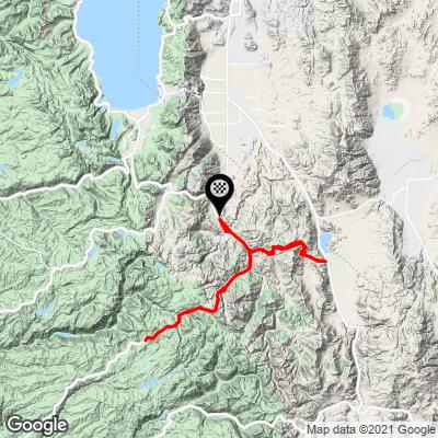
DEATH RIDE RIDE STATS:
- 104.2 Miles
- 14,399’ gained (full ride)
- Gradient Review:
- 50% of the ride is at 0% elevation or is descending;
- 23.9% at 0-5%
- 21.9% at 5-10%
- 3.7% at 10-15%
- < 1% at 15-20%
- ¼ mile = 12.5% on Ebbetts Pass West
- ½ mile = 11% on Monitor Pass East
- 1 mile = 10% on Monitor Pass East
- Climbs ranked by difficulty (in PJAMM’s experience and opinion)
- Monitor East
- Ebbetts East
- Monitor West
- Ebbetts West
- Pacific Grade East
- Pacific Grade West

Five passes (you go over Monitor and Ebbets twice).
The Death Ride is an extremely challenging yet fun event. It is very well organized and in our three times participating, we have never had any form of bad experience - it’s all good . . . well, except for 127 miles and 15,000’ of climbing in one day - OUCH!
INTERESTING AND IMPORTANT FACTS:
- 2021 is the 40th Anniversary of the Death Ride
- This was a timed race until 1987
- This event began as a gathering of 17 friends looking for a challenge.
- Check in is from 11:00 a.m. to 7:00 p.m. Friday before the ride, or beginning at 4:00 a.m. the morning of the event.
- The official start time is 5 a.m. or later (but, many people begin earlier)
- You must be off the course by 6:30 p.m.
- Ice cream this year is at the end, as the customary ice cream spot was Carson Pass.
- KOM for Death Ride 2021 Route: Peter Stetina at 5:15:45 (Strava Page).
HERE ARE YOUR OPTIONS
Climb | Distance | Elevation Gain | Average Grade | FIETS INDEX | Summit Elevation |
Monitor West | 8.2 | 2,636 | 6.2% | 6.36 | 8,330 |
Monitor East | 9.5 | 3,227 | 6.7% | 7.91 | 8,330 |
Ebbetts East | 11.4 | 2,954 | 5.2% | 6.02 | 8,750 |
Ebbetts West | 5.2 | 1,678 | 6.0% | 4.78 | 8,750 |
Pacific Grade East | 2.3 | 963 | 7.9% | 3.8 | 8,050 |
Pacific Grade West | 6 | 929 | 2.3% | 2 | 8,050 |
Note: You may do as many passes as you wish, but they must be done in order. At each summit, you receive a sticker placed on your ride number identifying how many passes you have done. You must have six stickers for an All Pass jersey.
“ALL PASS FINISHERS: The all-pass-finishers, AKA "Tombstone Club", will receive the finishers' pin, and have the option to order the finisher's jersey and sign the official ride poster. A limited stock of Tombstone Club jerseys will be available for purchase at the Expo. Once those run out, we will take orders.” (Source: official info@deathride.com pre-race information and instruction email).
WEATHER
Note for 2021: Northern California is in the midst of an unprecedented seasonal heat wave. PJAMM's weather projections (see our weather tool for start and summit of each climb on the individual climb pages) for the area on event day is high 80s to low 90s, so consider beginning as early as possible, even before the official start at 5:15 a.m. from Turtle Rock. Bring headlights.
PARKING
We have always had good luck parking on Highway 89 near the entrance to Turtle Creek where the ride begins.
“PARKING: Parking at Turtle Rock Park is limited. We encourage carpooling, having a friend or loved one drop you off at the start, or getting there early to find a spot. Many riders park alongside the mowed areas of the roadside on Hwy 89 near the park area. Additional options include parking along Airport Road, or in Markleeville or Woodfords and cycling to the Start.” (Source: official info@deathride.com pre-race information and instruction email).
CHECK-IN
“Riders can check in to obtain their bibs, swag bags, t-shirts, and jerseys if you pre-purchased them, as well as sign the necessary waivers. Each rider MUST provide photo ID to receive their packet, and must be present. Check-in on Friday is from 11AM-7PM, and Saturday starts at 4AM. Unlike prior years, you will not receive any packet information or bibs in the mail.” (Source: official info@deathride.com pre-race information and instruction email).
START TIME AND ROAD CLOSURES
“Roads close at 5AM. Opening ceremonies begin at 5:15AM, and cyclists will be released in waves starting at 5:30AM. Riding prior to the official event start time is done so at your own risk, and aid stations/bib checks are scheduled to open in accordance with the official start time.” (Source: official info@deathride.com pre-race information and instruction email).
CLOTHING
“CLOTHING: Prepare for very cool temperatures in the morning and hot temperatures by mid to late morning. The temperatures in the Sierra Nevadas can drop drastically overnight. There will be drop bags available at the top of Monitor Pass as well as at the Topaz junction turnaround point. While the forcast currently 96 degrees, it is also common to have rainshowers and thunderstorms in the hot summer afternoons. Also prepare for greater susceptibility to sunburn at high elevations.” (Source: official info@deathride.com pre-race information and instruction email).
BIBS AND BIB STAMPS
“BIBS, BIB STAMPS: Bibs should be worn on your back and be visible at all times. There will be a bib check just before the junction to Monitor Pass. There are five (5) bib stamp locations throughout the course, and then a sixth at the Finish. It is critical that your bib be on your back so that the volunteers can quickly and safely place the appropriate pass stamp on your bib with minimal face to face contact. If your bib is not visible to course marshalls you may be stopped and asked to present your bib. "Poachers" will be escorted off the course.” (Source: official info@deathride.com pre-race information and instruction email).
SUPPORT ON THE RIDE
“SUPPORT: The fully supported course includes nine rest stops. Your official course map will indicates which of these are full rest stops with porta potties, water, electrolyte drink, snacks etc., which ones are water/electrolyte stops only, and where the lunch stop is located. To view the map on our Facebook page, click here. A cleaner version will be posted on the Death Ride website over the weekend. There will also be SAG throughout the course to assist if you feel you are unable to finish the ride or get to the closest aid station without support. Medical personnel will also be placed throughout the course to monitor rider health and safety.” (Source: official info@deathride.com pre-race information and instruction email).

START
The ride begins at Turtle Rock - early!

Nice pancake and egg breakfast.

Bring your lights and a windvest/jacket.
MONITOR WEST

Ride 8.2 miles gaining 2,648’ at 6.1% average grade.
PJAMM CYCLING’S PROFILE TOOL
This will be the easiest of the day because it is the first, and fairly mild with a consistent 6% average grade.

Start.

Monitor Pass.
MONITOR PASS EAST

Ride 9.5 miles gaining 3,261’ at 6.5% average grade.
PJAMM CYCLING’S PROFILE TOOL
This is the hardest climb of them all and a Top 100 US bike climb. It is a grueling 9.5 miles at 6.7% average grade. You will be ascending in the early morning so the temperatures, which can be stifling in the afternoon in the summer, will be mild and manageable.

Bottom of Monitor East - Start of Climb #2.

Monitor Pass . . . again . . .
EBBETTS PASS EAST

Ride 11.4 miles gaining 2,951’ at 4.9% average grade.
PJAMM CYCLING’S PROFILE TOOL
It’s starting to hurt now. This is the longest climb, and while it has only a 5.2% grade, has some steep segments to it (e.g. half a mile at 9.9%).

The steepest segment (quarter-mile at 10.9%).

Ebbetts Pass.
PACIFIC GRADE EAST

Ride 2.3 miles gaining 963’ at 7.9% average grade.
PJAMM CYCLING’S PROFILE TOOL
Pacific Grade is new to the Death Ride this year. Carson Pass has been eliminated and replaced with Pacific Grade. We feel this greatly improves the quality of the ride because Caron Pass is extremely busy with fast moving traffic and the west side of Ebbetts (including Pacific Grade) replacing it is much more scenic, peaceful, and quiet.

Cycling Pacific Summit
Ride 2.3 miles gaining 963’ at 7.9% average grade.
This is a fairly short climb but it packs a bit of a punch because the gradient is not uniform. Instead there are several steep sections interspersed with shallower sections. It is difficult to get into a rhythm with the different slopes. It might be tempting to just power through the steep sections, but slow and steady could be a better approach.

PACIFIC GRADE SUMMIT WEST

Ride 6 miles gaining 929’ at 2.3% average grade (4.2% climb only).
PJAMM CYCLING’S PROFILE TOOL
EBBETTS PASS WEST

Ride 5.2 miles gaining 1,654” at 6% average grade.
PJAMM CYCLING’S PROFILE TOOL
The fifth and final leg of the Death Ride is blessedly short at 5.2 miles (6% average grade).

Bottom of Ebbetts Pass West.


Ice cream at the finish!