Cycling Mount Teide from Las Cristianos, Spain
Ride 33.2 kilometers gaining 2,109 meters at 6.4% average grade.
This is one of the most popular routes to the top of the most popular destination in the Canary Islands: Mount Teide. This route ranks #73 in the world and ends at the Teide National Park Sign, but do continue past the sign to the Visitor Center and paved high point of the road and island - this is the most scenic part of the climb and takes you in view of Mount Teide and its unique volcanic formations.

Strava’s leaderboard for all segments up the mountain proves to be a testament to the popularity of Tenerife and Mount Teide. The leaders include professional cyclists with familiar names: Froome, Porte, Pinot, and more.

This is the southwestern approach to the massive Mount Teide volcano. Mount Teide is a volcano on Tenerife in Spain’s Canary Islands, and is the highest point in Spain and above sea level of all the Atlantic Islands. The highest point of Mount Teide is 3,718m (12,198’). The southern approaches to the summit have moderate traffic at the start due to the tourist towns they start in: Los Cristianos (southwest), and El Medano (southeast). Los Cristianos is a large city (population 21,235) which caters to tourists and has a ferry port. Much of the traffic we encounter along this long 52 kilometer climb is enroute to the same destination as we are, the National Park and Mount Teide.
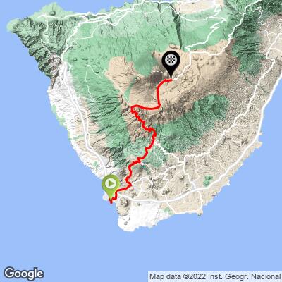
SIX POPULAR ROUTES UP MOUNT TEIDE

PJAMM Google Map with six of the most popular routes up Mount Teide.
The routes in counterclockwise order beginning with Mount Teide in El Medano (Southeast):
- El Medano: 38.3 kilometers gaining 2,289m at 5.7% average grade ending at the park sign on TF-21
- Los Cristianos: 33.2 kilometers gaining 2,109m at 6.4% ending at the park sign on TF-21
- Los Gigantes: 36.6 kilometers gaining 2,068m at 5.6% ending at highpoint on TF-38
- Puerto de la Cruz: 47 kilometers gaining 2,429m at 5% ending at the highpoint on TF-21
- Santa Cruz de Tenerife: 62.5 kilometers (longest climb in Europe) gaining 2,827m at 3.7% ending at TF-21 highpoint
- Guimar: Ride 48.9 kilometers gaining 2,508m at 4.4% ending at the highpoint on TF-21
SEGMENT ONE

Los Cristianos to Vilaflor.
Ride 20.8 kilometers gaining 1,264 meters at 6.1% average grade.
The first segment is a climb from the popular oceanfront tourist town of Los Cristianos to the lovely mountain town of Vilaflor. We enjoyed our stay at Hotel Spa Villalba in Vilaflor during our trip to Tenerife, and felt it was well located on the mountain for cycling the multiple routes up the flanks of Mount Teide.

We ride along TF-51 for much of this route.

There are signs on every approach to Mount Teide that identify the number of deaths on the road for the past five years. However, all the routes and climbs on the island, while many had moderate to heavy traffic (depending on the day and time of day) we always felt safe on our rides.

Arona is a good alternative to start if you do not wish to ride with traffic from Los Cristianos.
From Arona the ride is 25.3 kilometers, gaining 1,592 meters at 6.3% average grade to the Park Sign.

Turn left onto TF-21 at kilometer 20.8 as you reach Vilaflor.
SEGMENT 2

Vilaflor to the National Park Sign:
Ride 12.3 kilometers gaining 842 meters at 6.9%.
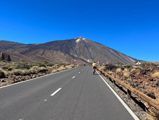
This is the most scenic segment of the true climb (we do recommend continuing past the park sign to the Visitor Center and also the road’s high point beyond that). We are in an alpine setting for the majority of this segment. All approaches to Mount Teide include a substantial amount of time in an alpine environment.

As with the entire route, this segment is consistently in the 6-8% range.
THE PARK SIGN

Along with photos with Mount Teide in the background, this is the top photo opp location on the mountain.
There are just two of the big metal National Park signs - on this route and the one up T-38 from the west.
![]()
![]()
El Retamar is the high point of this climb.
PARK SIGN TO VISITOR CENTER

Ride 15.8 kilometers from the sign to the Visitor Center.
This segment is the most scenic part of the 52 kilometer route to the paved high point of the mountain (Los Cristianos to High Point). There is an eight-kilometer descent averaging 2.3%, and descending 236 meters after the park sign, followed by 7.8 kilometer climb at 4.2% to the Visitor Center.

The views along the last seven kilometers of this segment are stunning.

It is nearly mandatory to ride from the park sign at least to the Visitor Center.

There are four primary access routes to the Visitor Center -
TF 21 (north and south) TF 38 (west) and TF 24 (north) and TF-525 (east).
VISITOR CENTER TO HIGH POINT

From the Visitor Center it is another six kilometers to Tenerife’s highest paved point.

Sign at the high point.
This is also Montaña Blanca and the trailhead for the hike of 8.3 kilometers (5.16 miles one way) gaining an incredible 1,188 meters (3,897’) to Mount Teide Peak (you can see the hike on our interactive map from our PJAMM Adventure App). Note: To hike to Mount Teide summit you must have a permit (apply here). The Teide Cable Car parking lot is just past the finish of our climb - Google Map of Teide Cable Car. With a cable car ticket, one can hike to the top and ride the cable car down, but you’ll have to hike 2.3 kilometers back to the trailhead if you don’t have a ride at the bottom of the cable car.
VISITOR CENTER

Food, beverages, bathroom and extraordinary views from the VC.

TRAM

The tram is accessed 3.4 kilometers at 4.6% past the Visitor Center. The tram will take you to near the top of Mount Teide. If you wish to hike to the highest point in Spain, get those tickets well in advance of your trip - we were told two months at the information booth in October 2022 (Official Website). Because of an unseasonal rainstorm the tram was not running during our trip.


Wintery conditions on Mount Teide in March.
The steepest five kilometers on this route begin just south of Vilaflor (highest village in Tenerife at 1,400 meters) at kilometer 23.7 (7.5%). We enter Teide National Park at kilometer 26, just north of Vilaflor. We are in an alpine setting for about 14 kilometers after leaving Vilaflor, before we rise above treeline for the remaining 14 kilometers at about kilometer 25.

Mount Teide - the highest point in Spain at 3,718 meters (12,198’).
Ron Hawk’s water bottle collapsed on his climb.

Bike Point - five locations on Tenerife.
Center Photo - Alberto Delgado (center) - Tenerife Cycling Tours - HIGHLY recommended!
Bike rentals on Tenerife can be obtained via: (a) Bike Point (five locations), and (b) Free Motion which has Specialized, Cannondale, and Pinarello rentals, and is endorsed by our cycling friend Bo Jensen, who has significant experience cycling the Canary Islands.

Paradores are Spanish government owned luxury hotels. The Parador on Tenerife is located at the Visitor Center and is the best location to stay, though it is pricey, for cycling the many routes up to Mount Teide. The professionals stay here because it also provides altitude acclimation (situated at 2,100 meters). The cost of Parador de Las Canadas del Teide was about twice the cost of our Vilaflor hotel (Villalba Hotel Spa; 85 versus 160 euros).