Cycling Mount Teide from Puerto Los Gigantes, Spain
Ride 36.4 kilometers gaining 2,058 meters at 5.6% average grade.
This ride begins in Port of the Giants - named after the giant rock formations, called Acantilados de Los Gigantes, which rise from the sea to a height of nearly 800 meters. These cliffs are one of the major tourist attractions on the island and a great spot to begin a ride that ends at the greatest tourist attraction on all the Canary Islands, Mount Teide.

START

These photos show the sheer rock walls of Acantilados de Los Gigantes after which the town is named.
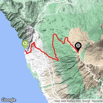
SIX POPULAR ROUTES UP MOUNT TEIDE

PJAMM Google Map with six of the most popular routes up Mount Teide.
The routes in counterclockwise order beginning with Mount Teide in El Medano (Southeast):
- El Medano: 38.3 kilometers gaining 2,289m at 5.7% average grade ending at the park sign on TF-21
- Los Cristianos: 33.2 kilometers gaining 2,109m at 6.4% ending at the park sign on TF-21
- Los Gigantes: 36.6 kilometers gaining 2,068m at 5.6% ending at highpoint on TF-38
- Puerto de la Cruz: 47 kilometers gaining 2,429m at 5% ending at the highpoint on TF-21
- Santa Cruz de Tenerife: 62.5 kilometers (longest climb in Europe) gaining 2,827m at 3.7% ending at TF-21 highpoint
- Guimar: Ride 48.9 kilometers gaining 2,508m at 4.4% ending at the highpoint on TF-21
SEGMENT 1

Ride from Los Gigantes to Chio 12 kilometers at 6% average grade.
SEGMENT 2

Ride 24 kilometers on TF-38 from Chio to the road’s highpoint (2,078 meters) at 5.5% average grade.

Views to the west (our left) as we climb north on TF-38 around kilometer 25.

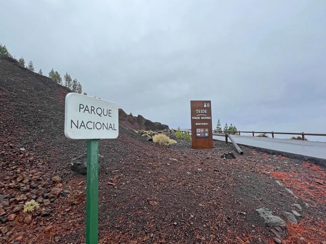
National Park sign at kilometer 31.7.
There are only two of the big metal National Park Signs on Mount Teide: one on this route and the one from Los Cristianos/El Medano from the south.
![]()
There are many informational signs along the climb.

Sign near the finish - not sure the route they used to conclude 39, but ours is 36 kilometers to Gigantes.

Finish at the high point on TF-38.
FINISH TO VISITOR CENTER

Turn left onto TF-21 2.3 kilometers after the finish.
There is a 7.9 kilometer, 112 meter descent at -0.86% (roughly flat), and then 2.2 kilometers at 5.5% to the Visitor Center.

The views along the last 6.7 kilometers of this segment after turning onto TF-21 are stunning.

It is nearly mandatory to ride from the finish to at least the Visitor Center.

There are four primary access routes to the Visitor Center:
TF 21 (north and south), TF 38 (west), TF 24 (north), and TF-525 (east).
VISITOR CENTER TO HIGH POINT

From the Visitor Center it is another six kilometers to Tenerife’s highest paved point.

Sign at the high point.
This is also Montaña Blanca, and the trailhead for the hike of 8.3 kilometers (5.16 miles one way) gaining an incredible 1,188 meters (3,897’) to Mount Teide Peak. Note: To hike to Mount Teide summit you must have a permit (apply here). The Teide Cable Car parking lot is just past the finish of our climb - Google Map of Teide Cable Car. With a cable car ticket, one can hike to the top and ride the cable car down, but you’ll have to hike 2.3 kilometers back to the trailhead if you don’t have a ride at the bottom of the cable car.
VISITOR CENTER

Food, beverages, bathroom, and extraordinary views from the VC.

We encounter several climate zones and ecosystems along the climb. We ride from the ocean, through alpine forest, into a transition segment with lower vegetation and broom scrub, to the stark volcanic landscape after the park sign on the way to the high point of the TF-21 and any road on Tenerife.
“The plant world is another of the outstanding features of the Mt. Teide National Park, where plant species are fully adapted to the tough living conditions of high altitude, intense sunlight, extreme temperature variations and lack of moisture. The vegetation has colonized this world of lava step by step, putting down roots in the almost inexistent, but nutrient and mineral rich soil, where lichens usually form the only vegetation cover of non-vascular flora that covers the recent lava flows of the Park. Hence, the diversity of plant species in the Mt. Teide National Park has a striking wealth, including an abundance of species that are endemic either to the island, regionally or even locally endemic” (Wonderfultenerife.com, flora and fauna of Mount Teide).
TRAM

The tram is accessed 3.4 kilometers at 4.6% past the Visitor Center. The tram will take you to near the top of Mount Teide. If you wish to hike to the highest point in Spain, get those tickets well in advance of your trip - we were told two months at the information booth in October 2022 (Official Website). Because of an unseasonal rainstorm the tram was not running during our trip.


Wintery conditions on Mount Teide in March.

Bike Point - five locations on Tenerife.
Center Photo - Alberto Delgado (center) - Tenerife Cycling Tours - HIGHLY recommended!
Bike rentals on Tenerife can be obtained via: (a) Bike Point (five locations), and (b) Free Motion which has Specialized, Cannondale, and Pinarello rentals and is endorsed by our cycling friend Bo Jensen, who has significant experience cycling the Canary Islands.

Paradores are Spanish government owned luxury hotels. The Parador on Tenerife is located at the Visitor Center and is the best location to stay, though it is pricey, for cycling the many routes up to Mount Teide. The professionals stay here because it also provides altitude acclimation (situated at 2,100 meters). The cost of Parador de Las Canadas del Teide was about twice the cost of our Vilaflor hotel (Villalba Hotel Spa; 85 versus 160 euros).