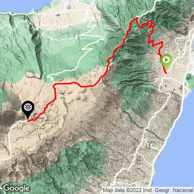
Cycling Mount Teide from Guimar
Ride 49 kilometers gaining 2,508 meters at 4.4% average grade (6.2% climb only).

This is the least cycled of our six routes up Mount Teide and is the primary approach from the east. The ride is on TF-523 for the first 21 kilometers at 6.6% average grade before the merge with TF-24 from Santa Cruz (the longest climb in Europe).
SIX POPULAR ROUTES UP MOUNT TEIDE

PJAMM Google Map with six of the most popular routes up Mount Teide.
The routes in counterclockwise order beginning with Mount Teide in El Medano (Southeast):
- El Medano: 38.3 kilometers gaining 2,289m at 5.7% average grade ending at the park sign on TF-21
- Los Cristianos: 33.2 kilometers gaining 2,109m at 6.4% ending at the park sign on TF-21
- Los Gigantes: 36.6 kilometers gaining 2,068m at 5.6% ending at highpoint on TF-38
- Puerto de la Cruz: 47 kilometers gaining 2,429m at 5% ending at the highpoint on TF-21
- Santa Cruz de Tenerife: 62.5 kilometers (longest climb in Europe) gaining 2,827m at 3.7% ending at TF-21 highpoint
- Guimar: Ride 48.9 kilometers gaining 2,508m at 4.4% ending at the highpoint on TF-21
MOUNT TEIDE FROM GUIMAR
![]()
![]()
This climb begins in Guimar (pop. 19,739 in 2018) on northeastern side of Tenerife.
![]()
There are many wonderful viewpoints along this climb.
![]()
After suffering four kilometers through a crowded urban setting, we transition into a more suburban and agricultural area and leave all residences behind around kilometer 11.

We ride through alpine forest for about 10 kilometers beginning around kilometer 18.

This ride is into and through one of Spain’s most popular national parks - Teide Parque National.
![]()
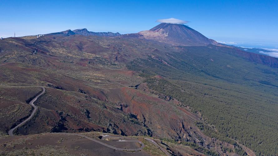
There are many views of Mt. Teide on this route and just as many great photo opps!
![]()
Extraordinary striation at km 29.5
This is a UNESCO World Heritage Site and is one of the 12 Treasures of Spain.
“Teide National Park - Situated on the island of Tenerife, Teide National Park features the Teide-Pico Viejo stratovolcano that, at 3,718 m, is the highest peak on Spanish soil. Rising 7,500 m above the ocean floor, it is regarded as the world’s third-tallest volcanic structure and stands in a spectacular environment. The visual impact of the site is all the greater due to atmospheric conditions that create constantly changing textures and tones in the landscape and a ‘sea of clouds’ that forms a visually impressive backdrop to the mountain. Teide is of global importance in providing evidence of the geological processes that underpin the evolution of oceanic islands” (UNESCO - Teide National Park).
![]()
There are about 12 observatories along TF-24 34.8 km from the start and 13.5 km from the finish.

![]()
Teide Observatory is a group of about 19 solar, nocturnal, and radio telescopes located on the northeastern portion of Teide National Park. This facility opened in 1964 and was one of the world’s largest international observatory operations. Later, observatory priority shifted to Roques de los Muchachos, which now hosts the largest telescope in the world (see PJAMM’s Roques de los Muchachos climb page). There is a visitor center, but you must sign up for a tour in advance - you cannot just drive up to the telescopes - there is a gate and guardhouse blocking the road at the bottom.
![]()
From the home page for the Teide Observatory:
“Experience the scientific side of Tenerife with a Teide Observatory visit
There’s so much more to Tenerife than the sun and the beach. Inland, almost half of the island lies within the Canary Islands’ Network of Protected Natural Spaces, and a good proportion also belongs to the Natura 2000 Network, which aims to ensure the long-term survival of Europe’s most threatened species and habitats. That may give you a clue as to the environmental importance and richness of Tenerife. The island holds several international awards from UNESCO to attest to its natural and cultural wealth. The Teide National Park has been declared a World Heritage Site, as has the city of San Cristóbal de La Laguna, while the Macizo de Anaga is a World Biosphere Reserve” (Read more or buy tickets).

There is a transition zone of lower vegetation including alpine broom scrub between km 28 to T-24’s merge onto TF-21 at kilometer 40.4. After that you are on the barren moonscape of the Volcano Teide.
“The plant world is another of the outstanding features of the Mt. Teide National Park, where plant species are fully adapted to the tough living conditions of high altitude, intense sunlight, extreme temperature variations and lack of moisture. The vegetation has colonized this world of lava step by step, putting down roots in the almost inexistent, but nutrient and mineral rich soil, where lichens usually form the only vegetation cover of non-vascular flora that covers the recent lava flows of the Park. Hence, the diversity of plant species in the Mt. Teide National Park has a striking wealth, including an abundance of species that are endemic either to the island, regionally or even locally endemic” (Wonderfultenerife.com flora and fauna of Mount Teide).

View of TF-24 as it climbs towards and passes Teide Observatories (left);
Mount Teide top center.

Turn left onto TF-21 at kilometer 40.4 after a 6.1 kilometer -4.3% descent.

The Teide caldera and the final kilometers of TF-21 to the finish.

Minas de San Jose at kilometer 47 just before the finish.

Finish at the highest paved point on Tenerife.
This is also Montaña Blanca and the trailhead for the hike of 8.3 kilometers (5.16 miles one way) gaining an incredible 1,188 meters (3,897’) to Mount Teide Peak (you can see the hike on our interactive map from our PJAMM Adventure App). Note: To hike to Mount Teide summit you must have a permit (apply here). The Teide Cable Car parking lot is just past the finish of our climb - Google Map of Teide Cable Car. With a cable car ticket, one can hike to the top and ride the cable car down, but you’ll have to hike 2.3 kilometers back to the trailhead if you don’t have a ride at the bottom of the cable car.

We feel this route has the best views of Mount Teide of any other approach.

The Teide volcano is the highest mountain in Spain and the highest volcano in the Atlantic Ocean. It is also the third-highest volcano in the world from its base in the ocean floor.
FINISH TO VISITOR CENTER

Six kilometers from the finish to the Visitor Center; 2.3 kilometers to the Mount Teide Tram.

The trip from the high point to the Visitor Center is generally downhill.
VISITOR CENTER

Food, beverages, bathroom, and extraordinary views from the VC.

TRAM

The tram is accessed 2.3 kilometers past the finish of this climb. The tram will take you to near the top of Mount Teide. If you wish to hike to the highest point in Spain, get those tickets well in advance of your trip - we were told two months at the information booth in October 2022 (Official Website). Because of an unseasonal rainstorm the tram was not running during our trip.


Wintery conditions on Mount Teide in March.

Bike Point - five locations on Tenerife.
Center Photo - Alberto Delgado (center) - Tenerife Cycling Tours - HIGHLY recommended!
Bike rentals on Tenerife can be obtained via: (a) Bike Point (five locations), and (b) Free Motion which has Specialized, Cannondale, and Pinarello rentals and is endorsed by our cycling friend Bo Jensen, who has significant experience cycling the Canary Islands.

Paradores are Spanish government owned luxury hotels. The Parador on Tenerife is located at the Visitor Center and is the best location to stay, albeit pricey, for cycling the many routes up to Mount Teide. The professionals stay here because it also provides altitude acclimation (situated at 2,100 meters). The cost of Parador de Las Canadas del Teide was about twice the cost of our Vilaflor hotel (Villalba Hotel Spa; 85 versus 160 euros).