Etna Summit West Bike Climb - PJAMM Cycling

8.3
FIETS
6.9 mi
DISTANCE
3,022 ft
GAINED
8.2 %
AVG. GRADE

FULL CLIMB STATS

Page Contributor(s): Bruce Hamilton/Stacy Topping. Ron Hawks, Las Vegas, Nevada, USA.

INTRO

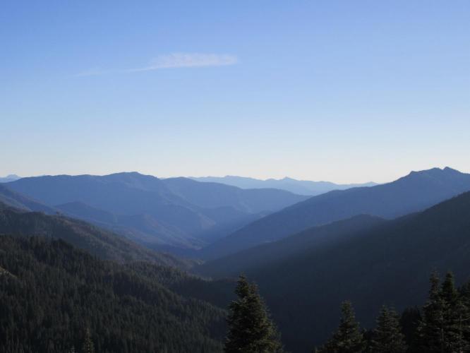
This is an extremely remote cycling climb in a rugged area of Northern California over which the Pacific Coast Trail passes. The views at the summit are spectacular and the bike climbs from both sides are certainly routes that should be considered when traveling through or staying in Northern California along the I-5 corridor. This cycling climb is one of the four Top 100 Climbs in Northern California/Southern Oregon that are in close enough proximity to climb on a 2-3 day trip to the area. The climb ends at the Pacific Crest Trail.
Average grade is 8.3% (8.6% climb only).  43% of the climb is at 5-10% grade and 29% is at 10-15%.  The steepest quarter-mile is 15.3% and steepest mile is 12%.  

See more details and tools regarding this climb's grade via the “Profile Tool” button.
Roadway:  This is a two lane road with no center stripe for the first third, transitioning to a center strip with two clearly designated lanes for the final portion of the climb.  The roadway is in fair to good condition with no shoulder.

Traffic:  Zero to minimal traffic.

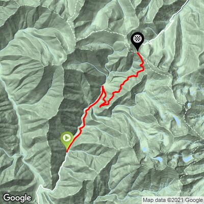
Parking:  We parked at the top and did both sides of the climb using that spot as our hub.  Otherwise, there is a small dirt turnout at Little China Gulch, half a mile before the start of our climb (MapStreet View). 
Provisions: 18 miles north in Etna (Map). 
Before heading out on any cycling adventure check out our Things to Bring on a Cycling Trip and use our interactive check list to ensure you don't forget anything.
Consider riding both sides of this climb together, as we did (adding Etna Summit East - 29 miles gaining 5,790' - Map).  

Use the “Routes in Area” button on the menu bar to see the many other bike climbs in this area. 

ROUTE MAP

MEMBER RATING

Difficulty: Challenging
3
Road
5
Traffic
4
Scenery

CURRENT WEATHER

PJAMM TRIPS ADVENTURE STARTER BUNDLES

Check out PJAMM Adventure's prepackaged (self-guided) cycling trips. They will help you plan, document and conquer your next adventure.
ALL TRIPS
Browse all of our prepackaged trips and find your next adventure!

NEARBY CLIMBS (0) RADIAL PROXIMITY

FROM
No Climbs Found

MEMBER REVIEWS & COMMENTS

Let us know what you thought of this climb. Signup for our FREE membership to write a review or post a comment.
Already have an account?

Apr 9, 2021
difficulty: Challenging
scenery: 4
traffic: 5
road: 3
Apr 9, 2021
scenery: 4
traffic: 5
road: 3
A great and isolated climb that you have to work just to get to. I like that it begins as mild but ends up difficult with most of the last 3 miles double digit grade. Very scenic summit as well.
ROUTE MAP
PROFILE TOOL
Route Data
S.G. (%)
hide
Segment Data
hide

Climb Profile Not Found
CLIMB SUMMARY

IMG_6323.JPG

Cycling Etna Summit from the West is a US 100 Bike Climb

Ride 22.5 miles gaining 5,613’ to elevation 10,500 at 4.1% average grade.


Etna Summit West is an extremely remote climb in a rugged area of Northern California over which the
Pacific Coast Trail passes.  The views at the summit are spectacular [see photo] and these are certainly climbs that should be considered when travelling through or staying in Northern California along the I-5 corridor. Although in a remote area, this is one of the 4 Top 100 Climbs in Northern California/Southern Oregon that are in close enough proximity to climb on a 2-3 day trip to the area.[1] 

Approaching Etna Summit from the west.

IMG_6323.JPG

View from the summit

PJAMM at Etna Summit - yeah!

ETNA SUMMIT WEST

The second half of this climb is a beast!  We hit and stay at double digit grades from miles 3.9 to 6.4 (average grade over this stretch is a whopping 11.1%).  Etna West is very remote, with little traffic, so bring appropriate provisions and tools - it can be a bit unnerving riding away from civilization down through the wide canyon that takes us to the bottom of the mountain and beginning of this climb.  However, for those adventurers among us - it’s a blast!

IMG_6290.JPG

“Hogan Mine” . . . the only sign of life we saw on this climb.

The roadway is in decent condition and one lane with no shoulder for the first 3.7 miles, then inexplicably turns to a fairly wide 2 lane road with double yellow center stripe at mile 3.7 which continues up and over the summit and for a few miles down the east side before turning back to a single lane (a real head-scratcher, that).

IMG_6285.JPG   

IMG_6293.JPG


For most of the lower portion of the climb, we are surrounded by forest, so no distant views.  However, towards the top of the climb, as we approach the Pacific Coast Trail, the view opens and we can see distant ridges to the west and east  that are breathtaking.

Steepest ¼ mile begins at mile 3.9 (15.4%) and steepest mile at 5.5 (12.1%)

ETNA SUMMIT EAST

The east side of Etna Summit is not as steep as the west, yet it is still a very pleasant ride and well worth an up-and-over.  The roadway (until near the top when it widens) is generally one wide lane, follows Etna Creek (although it is rarely actually in view) and is surrounded by forest until we near the summit. The narrow, tree-bordered roadway in this very remote area with minimal traffic gives us a very private feel and makes for a very comfortable and peaceful ride.
East/West Etna can be done as a great out-and-back route from the tiny Northern California town of Etna.  Here is a
Map of the out-and-back route. Overall, Etna Summit is a beautiful and challenging climb that should be included in your Northern California climbing itinerary.

IMG_2509.JPG

About 1.5 miles from the summit.  


IMG_2509.JPG

Summit - looking from the east side to the western descent.

Steepest ¼ mile and mile  begin at mile 3.2 (13.5% and 11.1% respectively)


[1]  #59 Mt. Shasta 68 miles southeast,  #86, Parks Creek East  73 miles east (via a roundabout route - not many direct routes in those parts)  and #95 Mt. Ashland 80 miles north, just across the southern Oregon border.