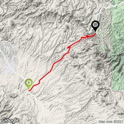
AZ State Road 78 Bike Climb - PJAMM Cycling

3.9
FIETS
13.9 mi
DISTANCE
2,933 ft
GAINED
3.6 %
AVG. GRADE

FULL CLIMB STATS

Page Contributor(s): Dan Razum, Campbell, CA, USA

INTRO

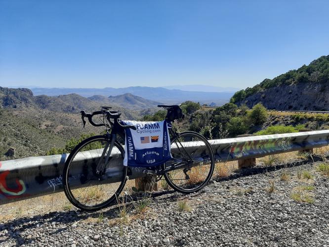
This 13.9 mile bike climb is located in AZ, USA. The average gradient is 3.6% and there is a total elevation gain of 2,933 ft, finishing at 6,313 ft.

Use the profile tool, route map, and weather forecast to conquer this cycling climb.

See more details and tools regarding this climb's grade via our interactive Profile Tool.
Road surface is good, traffic is very light but can be fast.

There's ample parking off to the side of the road or at the Three Way rest stop store.
After the Three Way convenience store, the climb is unsupported. There is a campground at the end with pit toilets.
Before heading out on any cycling adventure check out our Things to Bring on a Cycling Trip and use our interactive check list to ensure you don't forget anything.
This might not be the type of climb that you travel across the country to ride, but Southern Arizona as a whole absolutely is, and is one of the best climbing zones in the country. Must-do's in this area include:
  -  Mt. Graham (the hardest climb in Arizona)
  -  Morenci Mine (the most entertaining climb in the southwest!)
  -  Mt. Lemmon (one of the most famous in the country) 
  -  Kitt Peak (grueling climb up to a famous observatory)

Click here for hotel and rental recommendations in southern Arizona to take on these climbs. 

ROUTE MAP

MEMBER RATING

Difficulty: Moderate
4
Road
4
Traffic
4
Scenery

CURRENT WEATHER

PJAMM TRIPS ADVENTURE STARTER BUNDLES

Check out PJAMM Adventure's prepackaged (self-guided) cycling trips. They will help you plan, document and conquer your next adventure.
ALL TRIPS
Browse all of our prepackaged trips and find your next adventure!
Arizona: Cycling and Spring Training
United States (AZ)
17 ROUTES
48 POIs
ROUTE STATS (TOTAL)
360.3
mi
DISTANCE
33,516
ft
ELEV. GAIN
Arizona: Mt. Lemmon
United States (AZ)
11 ROUTES
28 POIs
ROUTE STATS (TOTAL)
62.4
mi
DISTANCE
16,765
ft
ELEV. GAIN
The American Southwest
United States (AZ,NM,UT)
18 ROUTES
27 POIs
ROUTE STATS (TOTAL)
215.4
mi
DISTANCE
34,866
ft
ELEV. GAIN

NEARBY CLIMBS (0) RADIAL PROXIMITY

FROM
No Climbs Found

MEMBER REVIEWS & COMMENTS

Let us know what you thought of this climb. Signup for our FREE membership to write a review or post a comment.
Already have an account?

Mar 20, 2021
difficulty: Moderate
scenery: 4
traffic: 4
road: 4
Mar 20, 2021
scenery: 4
traffic: 4
road: 4
Definitely worth the excursion from Three Way, a beautiful climb up to Black Jack campground. We combined it with US-191 which is a gentler climb west of Three Way. Strava activity with pics: https://www.strava.com/activities/4509790149
ROUTE MAP
PROFILE TOOL
Route Data
S.G. (%)
hide
Segment Data
hide

Climb Profile Not Found
CLIMB SUMMARY

Cycling Arizona State Road 78

Ride 13.9 miles gaining 3,085’ at 3.8% average grade (4.6% climb only).

Climb summary by PJAMM ambassador Dan Razum, Campbell, CA.

We started the climb about half way up, after the intermediate descent around mile 7. We start out

in a small ravine and climb through two 180 degree turns to arrive at a long straight section.

From this point you can see the top of the climb on the mountain in the distance.  This straight section has a moderate gradient and we can observe interesting scenery all around us.

After the straight section we pass over a cattle guard grate and enter Apache National Forest. We climb through several wide sweeping curves, with the final destination always in sight. As we climb higher, the views become more vast.  

Near the top there is a parking area with impressive views of the entire road below, and all the curves we just climbed.  

The parking area isn't quite the top though, so we need to climb a little further.  The actual top is where the road flattens

out, there isn't any indication or any views. A short distance past the top is Black Jack campground, with restrooms, if needed, but no water, unfortunately.

Overall, this is a beautiful climb with very nice views of the valley, the far off mountains and

the road below.  In the distance we can also see Morenci Mine, as a large white spot in the distance.

We definitely recommend this climb for the scenery.

Morenci Mine - white spot to the left.

The road is fairly wide, with a good shoulder in some parts, but not everywhere.  And the pavement is in good condition.  There is a fair amount of traffic on this climb, but not excessive, the climb felt safe.  There is no shade, so it is likely to be hot, unfortunately. Of course, if hot weather is a big issue for you, then you might want to think twice about cycling in Arizona in general.