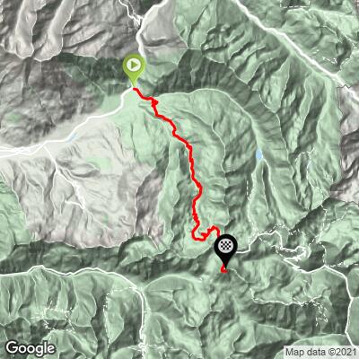
Cycling Cime Bonette from Jausiers, France
Ride 24 kilometers gaining 1580 meters at 6.4% average grade.
Often incorrectly considered the highest road in Europe (Pico de Veleta in Spain holds that honor, by a good stretch), this is the more challenging approach to Col de la and Cime Bonette at 23 km/1,632 m/6.9% from the, north versus 25.5 km/1,553 m/6.1% from Saint-Étienne-de-Tinée to the south. The pass itself is the third highest in Europe after Passo dello Stelvio (2760m) and Col de L’Iseran (2770m), but if we take the loop to Cime Bonette at the pass, we gain another 81m, which tops out above L’Iseran.

Col de la Bonette is located in the French Alps near the border with Italy. It is located within Mercantour National Park (established 1979; 169,000 acres).

The climb begins in Jausiers (2016 pop. 1,129) in the Alpes-de-Haute Provence of southeastern France.

This is an extremely scenic cycling experience.

KM markers along the route.

Halte 2000
Route du Col de Restefond
![]()
Due to its high elevation, you are likely to encounter snow near the top of this climb in the early cycling season, including June.

Caserne de Restefond (WW I barracks) at 20 kilometers.
This defensive fort was constructed in 1901 and served as a rear logistics base in June 1940 during the Battle of the Alps.

There’s not a lot of wildlife in this area . . . but we did encounter one furry critter . . .

Cime Bonette - 2862 meters.
Col de la Bonette is located 1 km below the high point of this road. At the col, we turn right and follow the 1 km ascent of the Cime de la Bonette loop, gaining 80 m at 9% average grade.

Cime de la Bonnet is located in the Maritime Alps, a subrange of the Alps.
Col de Bonette is part of the Route des Grandes Alpes, a tourist itinerary that begins in Thonon-les-Bains and travels over many of the most spectacular passes in France and Europe, including Col de L’Iseran, Galibier, d’Izoard, and Bonette; (alternate route includes Croix de Fer and Madeleine). The route connects Lake Geneva to the Mediteranean Sea.

Route des Grandes Alpes.
![]()
Monument at the highest point in Tour de France history
TOUR DE FRANCE HISTORY
Col de La Bonnette has been featured four times in the Tour de France as of 2019.
1962 stage 18 - 241.5 km Juan les Pins to Briancon
The tour jumped on Cima de la Bonette just two years after the road over the summit was completed. Stage 18 of the 1962 Tour de France began in the Mediterranean port town of Juan les Pins and ended 241.5 km later in the climbing hub of Briancon. Surprisingly, although the stage featured three major climbs (Bonette, Col de Vars, and finally Col d’Izoard) it was Belgium sprinter Emile Daems who won the stage in a sprint over Imerio Massignan and Jacques Anquetil sat second overall :00:01:08 back of Jozef Planckaert at the end of the day (he would gain the lead two stages later and go on to win his third of a then record five TdF championships that year).
However, and fittingly, it was the great Spanish Mountain King Federico Bahamontes (The Eagle of Toledo) who was first over the inaugural ascent of Bonette, July 11, 1962, stage 18. Bahamontes and Luis Herrera of Colombia are the only two cyclists in history to have completed the pure Grand Tour Triple Crown (KOM of the Tour de France, Giro d’Italia and Vuelta de Espana in the same year). If not the top climber of all time, Bahamontes is in the top five, winning the mountain classification six times in the TdF, two in the Vuelta, and one in the Giro.

Federico Bahamontes was the first TdF cyclist over Col de La Bonette (1968, Stage 18).
Bahamontes was also first over Bonette in 1964, stage 9.
Photo Bettina Verbeek, Flickr
1993 Stage 11 179 km Serre Chevalier to Isola
July 15, 1998 -- Stage 11 was won by Tony Rominger with the great Miguel Indurain (five straight TdF wins 1991-1995; two Giro 1992-1993), just behind in the same time (excellent YouTube summary by Phil Liggett).

Millar is only the second rider to lead the TdF over Col de La Bonette
Photo - Rouleur
It was all about Scotland's Robert Millar and French great Laurent Fignon on Bonette this memorable day in the TdF, for quite different reasons. Millar took off at the beginning of the Bonette ascent in Jausiers and within a minute was 20 seconds up on climbing great Pedro Delgado. Delgado clung for a bit, but ultimately fell off and Millar topped Col de La Bonette alone. He led on the descent but was ultimately overtaken by the peloton and finished an exact one minute down to Rominger and Indurain in Isola at the finish of the stage.
Laurent Fignon (1960-2010) had an illustrious Tour career (1983-1984 TdF, 1989 Giro) which came to a bittersweet end on Col de La Bonette July 15, 1993 as he dropped back from the peloton and ascended Col de La Bonette alone. In his autobiography, We Were Young and Carefree: The Autobiography of Laurent Fignon, he writes, “I can remember it very clearly. I rode up the whole climb in last place. Because I wanted to. I put my hands on the top of the bars and savoured it all to the full. I was breathing deeply as I lived through my last seconds in bike racing, which I had thought would never end for me. This col was all mine and I didn’t want anyone to intrude” (p. 259). Sadly, it is likely due to EPO use by the majority of his serious competitors that the honorable and clean Fignon could no longer compete, yet, he was the best of them. Laurent Fignon died of lung cancer at the young age of 50 on August 31, 2010.

Laurent Fignon 1983-1984 TdF Champion.
2008 Stage 16 157 km Cuneo, Italy to Jausiers, France

2008 stage 16 from St. Etienne. This stage began in Cuneo, Italy and reached Col de la Bonette via the Italian ascent and French descent of Col de la Lombarde. The stage ended in Jausiers when it was won by French climber Cyril Dessel in a sprint involving a group that broke away on the ascent of Bonette. Frank Schleck (LU) led the TdF by seven seconds over Austrian climber Bernhard Kohl.
While stage 16 was won by Dessel, and Schleck led at the end of the stage, this day in Tour history is more known for the spectacular crash of South African rider John Lee Augustyn at the beginning of the descent from the Cime de la Bonette loop road. Leading the race as it crested Bonette, Augustyn spectacularly overshot a 90 degree right hand curve and flew off the road and down a steep shale embankment (YouTube Video). Augustyn was helped back up to the road by a spectator and after checking himself and getting a replacement bike went on to finish an amazing 35th on the stage!

John Lee Augustyn climbing back up the hillside after his tumble.
Augustyn was only the third man ever to lead the TdF over Bonette.
Bahamontes (1962, 1964); Millar (1993)
Augustyn was forced to retire in May 2014 at the age of 30 due to hip damage sustained in a 2007 crash. Among other things, Augustyn now promotes his own line of cycling apparel, appropriately named . . . you guessed it . . . La Bonette.
(Col de La Bonette)
As of 2020, the col has not been featured in the Tour de France since 2008.
Wikipedia says of Cime de la Bonette:
“Cime de la Bonette (el. 2,860 metres or 9,383 feet) is a mountain in the French Alps, near the border with Italy. It is situated within the Mercantour National Park on the border of the departments of Alpes-Maritimes and Alpes-de-Haute-Provence, between the Ubaye Valley and the valley of the Tinée River.
"Cime" is French for "summit".
The summit is surrounded by a road from the Col de la Bonette, which reaches 2,802 metres (9,193 ft), and is the second highest paved through route in the Alps. It is also the highest point reached by the Tour de France.”

Cima Bonette -- highest paved “through point” (loop) in Europe.
Do not be confused by “Sol de la Restefond” references along the northern and southern approaches to Cime de la Bonette:
“Col de Restefond (el. 2,680 metres (8,790 ft)) is a high mountain pass in the French Alps, near the border with Italy. It is situated on the flanks of le Restefond within the Mercantour National Park in the department of Alpes-de-Haute-Provence.
The actual pass is situated on a gravel track leading off the D64 close to its summit at the Col de la Bonette (2715 m). The passage over the Col de la Bonette is often mistakenly referred to as the Col de Restefond, and in the 2008 Tour de France the summit was referred to as the Cime de la Bonette-Restefond. Stage 16 of the tour approached the summit from Saint-Étienne-de-Tinée (south-east), and after reaching the Col de la Bonette, took a loop round the Cime de la Bonette reaching the summit of 2802 m, which is the highest point reached by the Tour de France,[1] before re-passing the Col de la Bonette. On the descent to Jausiers, the actual Col de Restefond was passed on the right approximately 1 km from the summit,” (Col de Restefond).

Road sign from Jausiers.

Road sign from Saint Etienne.

Thank you to PJAMM Cycling friend and contributor Ard Oostra (CH) for his photo contributions to this page.