Quimby Road Bike Climb - PJAMM Cycling

14.4
PDI
4.5 mi
DISTANCE
2,016 ft
GAINED
8.5 %
AVG. GRADE

FULL CLIMB STATS

INTRO

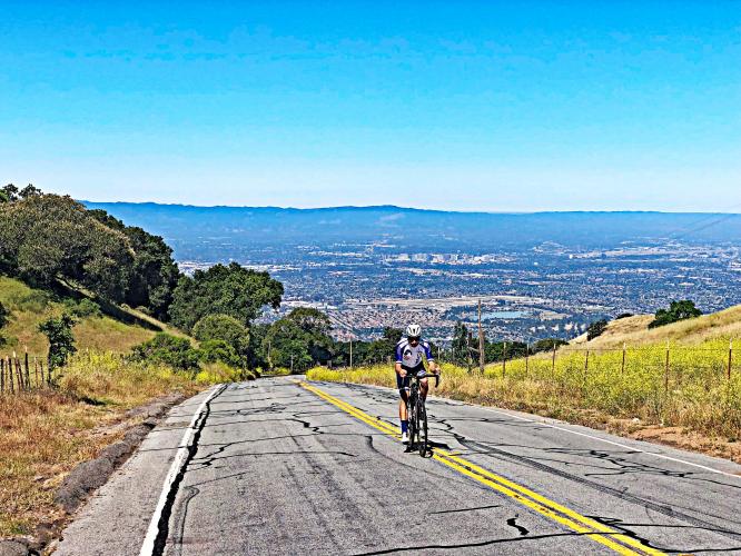
As with Mt. Hamilton West five miles north, there are some extraordinary views to the west of San Jose and the Silicon Valley on this challenging and top Santa Clara County bike climb. 

PLAN YOUR ROUTE

We've partnered with Sherpa-Map.com to bring you the best route planning tool. With a PRO Membership you can use this climb as a reference when creating your route.
After an initial 1.5 mile start that varies between -1% and 8%, the final three miles of this climb are fairly steadily between 8-11%.  The steepest quarter-mile of the climb is 13.5% and there is a continuous mile beginning at mile 3.2 that averages 13%.  42% of this ascent is at ≥10% grade.
 
See more details and tools regarding this climb's grade via the “Profile Tool” button.
Roadway:  Narrow with no shoulder and as of 2019, the roadway was in good condition.  

Traffic:  Mild.

Parking:  On weekends park at Evergreen High School at the start of the climb, or on the street near it: MapStreet View.  
There are no provisions along this bike climb.  
Before heading out on any cycling adventure check out our Things to Bring on a Cycling Trip and use our interactive check list to ensure you don't forget anything.
While in the area, consider other great climbs nearby - see PJAMM's climbs in Santa Clara County.  When traveling to the Santa Clara County to cycle, you might choose to stay in Saratoga or Santa Cruz. There are also great options for house rentals in the area.

Use the “Routes in Area” button on the menu bar above to see other bike climbs in this area.


ROUTE MAP

MEMBER RATING

Difficulty: Challenging
3
Road
4.3
Traffic
3
Scenery

CURRENT WEATHER

PJAMM TRIPS ADVENTURE STARTER BUNDLES

Check out PJAMM Adventure's prepackaged (self-guided) cycling trips. They will help you plan, document and conquer your next adventure.
ALL TRIPS
Browse all of our prepackaged trips and find your next adventure!
San Francisco Bay Area
United States (CA)
25 ROUTES
30 POIs
ROUTE STATS (TOTAL)
487.9
mi
DISTANCE
65,482
ft
ELEV. GAIN

NEARBY CLIMBS (0) RADIAL PROXIMITY

FROM
No Climbs Found

MEMBER REVIEWS & COMMENTS

Let us know what you thought of this climb. Signup for our FREE membership to write a review or post a comment.
Already have an account?

May 16, 2024
difficulty: Challenging
scenery: 3
traffic: 5
road: 3
May 16, 2024
scenery: 3
traffic: 5
road: 3
Not really too bad, only becomes tough if you don't stop and just continue till the top of hamilton.. then it becomes around 6k feet (1830m) of climbing. The last mile is pretty tough. I would not recommend descending this if you have the choice, hairpins are very sharp and STEEP. It is doable with caution just don't send it, do that on hamilton. There is a view around halfway to the top, nothing crazy just overlooks that area of San Jose.
Jun 3, 2021
difficulty: Challenging
scenery: 3
traffic: 4
road: 3
Jun 3, 2021
scenery: 3
traffic: 4
road: 3
The climb pretty much increases in intensity. The last mile was the most grueling for me. Even with a 1:1 gear ratio and a 3.7 w/kg ftp, I found myself quite strained to get to the top. There are some less steep bits where you can spin a bit to recover. It is quite technical descent as there are very steep hairpins, so I do not recommend descending from Quimby Rd. Instead, decent down 130 or Clayton Rd!
Jun 1, 2021
difficulty: Moderate
scenery: 3
traffic: 4
road: 3
Jun 1, 2021
scenery: 3
traffic: 4
road: 3
Really like this climb. Takes you away from city bustle through classic switchbacks and solid grade. Use it to get to Mt Hamilton if needed and it is an interesting descent.
ROUTE MAP
PROFILE TOOL
Route Data
S.G. (%)
hide
Segment Data
hide
CLIMB SUMMARY

Cycling Quimby Road, Santa Clara County, CA

Ride 4.5 miles gaining 2,017’ at 8.5% average grade.

Climb summary by PJAMM’s John Johnson.

This is a steep and challenging climb out of the Silicon Valley into a very rural area on a narrow road with minimal traffic.  We begin our climb in a suburban area near Quimby High School in East San Jose, but at the 1.1 mile mark we cross Murillo Avenue and are soon into an eclectic mix of ranchland together with the occasional Silicon Valley mansion.  If you leave in the early morning as we did, you’ll encounter roosters crowing, along with cows and horses grazing.  

Before heading to the bay area on your cycling adventure, be sure to rely on our list of Things to Bring on a Cycling Trip, and use our interactive checklist to ensure you don't forget anything.

Bike climb Quimby Road - aerial drone photo of San Jose and Silicon Valley

The Quimby Road bicycle climb ends at Joseph D. Grant County Park -- the largest of 28 county parks owned by Santa Clara County.  Quimby Road is in the Diablo Range of the Pacific Coast Mountain Range.

Windy road - no problem on the ascent, but . . .

. . . caution comin down . . . .

??

Reminds us a bit of a sign on Alto de Letras, Colombia

Bicycle climb of Quimby Road - horses and roadway, fields

This climb gets rural quick.  

  Bike ride up Quimby Road - roadway and windmill

Top of the climb.


There are excellent views of the Silicon Valley and San Jose to our west as we quickly rise out of the valley (because of the elevation gain, not our speed, that's for sure!).  Along with the first sections of
Mt. Hamilton Road West and Sierra Road in Santa Clara County, this climb provides the best views of the Silicon Valley from its eastern side.  

Bicycle climb of Quimby Road - horses and roadway, fields

Cycling  Quimby Road - PJAMM Tayler Hockett on bike with San Jose in background

PJAMM’s Tayler Hockett at the top of Quimby Road.

 
Descent:  The downhill on this one is technical and steep with very sharp turns/switchbacks that come up on you quickly, so descend with caution.

Roadway Surface and Traffic Report: The roadway is two lanes with a double yellow center stripe the entire climb.  There is minimal traffic along this route and it is safe for cyclists.