3.6
PDI
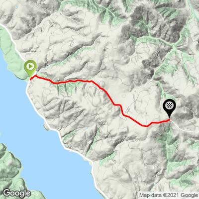
3.1 mi
DISTANCE
783 ft
GAINED
4.4 %
AVG. GRADE
FULL CLIMB STATS
INTRO
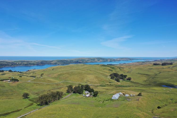
The Marshall Wall West and East climbs are located in the northwestern corner of Marin County and are quite rural and remote. The landscape is almost exclusively rugged pastureland with some views of the Pacific Ocean and Marin County's Arroyo Sausal Reservoir. This climb begins just off Hwy 1 and climbs past a neat old church and quickly into ranch and dairy land. Looking back along the first mile of the ride we have some nice views of Tomales Bay.
PLAN YOUR ROUTE
Average grade is 4.4% (5.6% for climb only). 15% of the route is descent, 31% 0-5% grade, 47% 5-10% and 6% is at 10-15% grade. The steepest quarter mile is 9.4%.
See more details and tools regarding this climb's grade via the “Profile Tool” button above.
Roadway: Two lanes in fair to good condition with no shoulder.
Traffic: Minimal - you are more likely to encounter a milk transport semi-truck and trailer than automobile.
Parking: At climb start in Marshall along Hwy 101 - Map; Street View.
Provisions: Hog Island Oyster is a cool restaurant and venue at the climb start, or in Inverness 14 miles south, Tomales Bay 21 miles south or Dillon Beach Resort 11 miles north.
Before heading out on any cycling adventure check out our Things to Bring on a Cycling Trip and use our interactive check list to ensure you don't forget anything.
A nice out and back ride this climb together with Marshall Wall East - 12 miles and 1,385' (Map).
There are some great places to stay in nearby Bodega Bay. There are many great house rentals in Marin County too.
ROUTE MAP
MEMBER RATING
CURRENT WEATHER
PJAMM TRIPS ADVENTURE STARTER BUNDLES
Check out PJAMM Adventure's prepackaged (self-guided) cycling trips. They will help you plan, document and conquer your next adventure.
NEARBY CLIMBS (0) RADIAL PROXIMITY
FROM No Climbs Found
MEMBER REVIEWS & COMMENTS
Let us know what you thought of this climb. Signup for our FREE membership to write a review or post a comment.
Already have an account?
LOG IN HERE
lirizar1
Really nice views of rolling open farmland and lots and lots of cows. Brought back memories of the Pyrenees! Very few cars along the ten miles on this road but road surface could be better with potholes mostly patched up. Steepest part of the climb was the kicker turning off of Highway 1.