![Cycling Pico de las Nieves from Telde, Canary Islands, Spain panoramic view of mountain and forest setting with beautiful mountain and plateau silhouettes in distance]()
Cycling Pico de las Nieves from Telde - a World Top 100 Bike Climb.
Ride 26.6 kilometers from 175m to 1933m gaining 1785m at 6.6% average grade.
The Canary Islands are a volcanically formed archipelago (group of islands) consisting of seven larger and several smaller islands. Tenerife is the largest of the islands, while Gran Canaria is the third largest and second most populous (third most populous in all of Spain behind Tenerife and Mallorca). This climb ends at the highest paved point on Gran Canaria at 1935 meters, and is the third highest point you can ride your bike to on any of the Canary Islands behind Roque de los Muchachos, Santa Cruz de La Palma (2,400 meters), and the high point on Mount Teide, Tenerife (2,366 meters).
Summary by PJAMM ambassador Ron Hawks of Henderson, Nevada.
This climb, which starts on GC-131 in the city of Telde, merges into GC-130 after a few miles and takes us to the highest peak in Gran Canaria. Telde is the oldest and second most populous city in Gran Canaria (founded in 1351, population 102,170) The spiritual center of Telde is the Church San Juan Bautista, located in the town square at the northern end of town, which was founded in 1483.
![Cycling Pico de las Nieves from Telde, Canary Islands, Spain beautiful and historic San Juan Bautista church, founded in 1483]()
San Juan Bautista
Traffic at the beginning of the climb was steady but manageable and the road is in good condition. However, once we merge onto GC-130 at kilometer 6.5 (at the two hairpins) the road quality declines and was fairly rough by Gran Canaria standards.
![Cycling Pico de las Nieves from Telde, Canary Islands, Spain photo collage shows PJAMM Cyclist riding on two-lane highway roadway in alpine setting]()
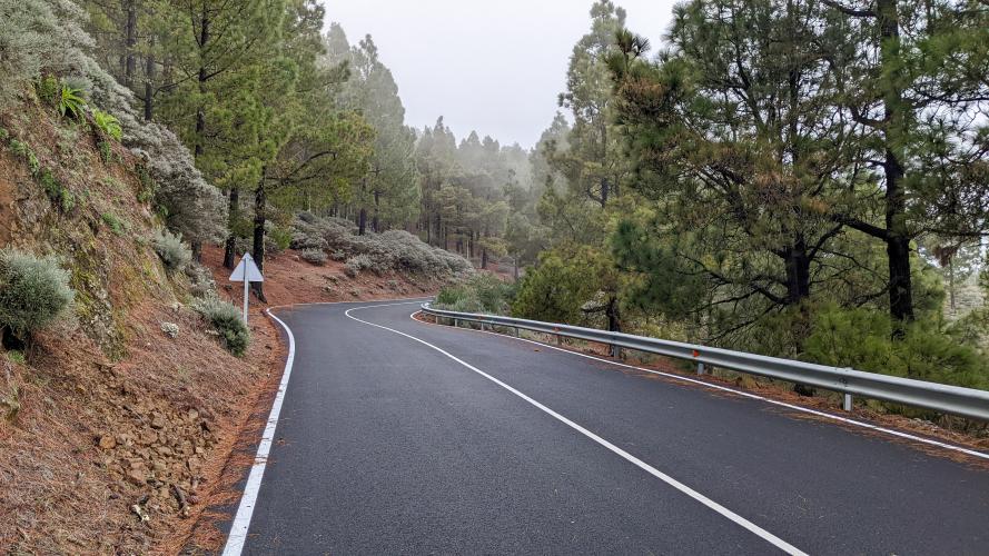
The grade was pretty stout throughout the climb (steepest kilometer 12%) with a lot of double-digit sections that got our attention as we looked for decent tarmac to ride. We are in forest and the road is bordered by Canary Island pines for a good part of the ride.
![Cycling Pico de las Nieves from Telde, Canary Islands, Spain photo collage shows forest setting, Canary Island pines]()
About 18 kilometers into our ride we have our first and only respite, with 2.1 kilometers that are effectively flat (0.7%). We get our first relief from a short descent that takes us past a beautiful viewing area formed by volcanic cauldron that’s worth a peek before the final ascent to the top.
![Cycling Pico de las Nieves from Telde, Canary Islands, Spain view looking down on Caldera Los Marteles Viewpoint]()
Caldera Los Marteles Viewpoint - kilometer 20.
![Cycling Pico de las Nieves from Telde, Canary Islands, Spain photo collage shows alpine and mountain views at the climb's finish, beautiful rock formations]()
Great views at the top.
Once we turn left and head south on GC-134 (km 25), the great tarmac returns for the last 1.7 kilometers to the top. The parking lot at the top is adjacent to a military base with a large green ball-shaped radar.
![Cycling Pico de las Nieves from Telde, Canary Islands, Spain photo collage shows sign for Mirador Pico de las Nieves, alpine setting, PJAMM cyclist standing next to informational signs, plateau along climb route]()
The climb finishes at an army base with a green radar ball.
There is a viewing platform from which, on a clear day, one can see much of Gran Canaria below, as well as Mount Teide to the northwest on Tenerife Island.
Wikipedia notes:
“Pico de las Nieves is the highest peak of the island of Gran Canaria, Canary Islands, Spain. Its height is 1,949 metres (6,394 ft) above sea level. The origin is volcanic (stratovolcano). On its slopes, Canary Islands Pine was reintroduced in the 1950s. It is the highest elevation of the province of Las Palmas and the third highest mountain in the Canary Islands. Of the other Canary Islands, only Tenerife and La Palma have higher peaks.
The name means 'peak of the snows' in Spanish and refers to the fact that several covered pits (neveras in Spanish) for holding snow were built directly into the mountainsides.. . . Most of the highest plateau is occupied by a military base, including a large ball-shaped radar. Civilian visitors are allowed to enter a platform somewhat below the base, from which half of the island as well as Tenerife's Pico del Teide is visible, in case of good weather. The most distinctive feature is the Roque Nublo monolith, the second highest peak of the island.”

 We've partnered with Sherpa-Map.com to bring you the best route planning tool. With a PRO Membership you can use this climb as a reference when creating your route.

