INTRO
PLAN YOUR ROUTE
 We've partnered with Sherpa-Map.com to bring you the best route planning tool. With a PRO Membership you can use this climb as a reference when creating your route.
 ROUTE MAP


 We've partnered with Sherpa-Map.com to bring you the best route planning tool. With a PRO Membership you can use this climb as a reference when creating your route.
Cycling Emigrant Pass East and West - from the East this is a Top 100 US bike climb.
From the east (Stovepipe Wells) ride ride 22.8 miles gaining 5,367’ to elevation 5,316’ at 4.4% average grade.
Visit our Death Valley National Park page
Start the Emigrant Pass East is in Stovepipe Wells, CA
California Top 10 Most Epic Climb
Emigrant Pass North begins in Stovepipe Wells, CA and is an extremely remote climb in Death Valley . The first several miles of this climb seem almost flat and we are definitely in an arid, desert-like setting. We begin to climb into more mountainous, yet barren, landscape around miles 7 and 8. As of October, 2014, there was water at the 9 mile point at Emigrant Campground. There is very little vegetation along this climb and no trees. As with most Death Valley climbs, the views are, not surprisingly, very stark and desert to high desert-like.
This sign greets us as we leave Stovepipe.
The first several miles of this bicycle climb seem almost flat and we are definitely in an arid, desert-like setting.
Ride on Hwy 190 for the first 9.3 miles - share this segment with Towne Pass East.
Stovepipe Wells is center right in photo (view east 4.6 miles from start)
Looking back down the mountain at mile 6
After riding 9.3 miles and just after passing Emigrant Campground, turn left onto Emigrant Canyon Road (9.3 miles at 4.5% average grade and 2,187' climbed to this point).
Emigrant Campground - turn left off Hwy 190 onto Emigrant Canyon Road here.
The next 7.6 miles are initially through a canyon and then into open upper desert space to the end point at Emigrant Pass.
Classic case of “when it rains, it pours . . . “
Looking back towards Hwy 190 just over a mile up Emigrant Canyon
Pass through a narrow and fun canyon for several miles 1 ½ miles after turning off Hwy 190
Riding in the canyon
Journigan Mill
There is a 4 mile 1.5% average grade section during the last part of the climb.
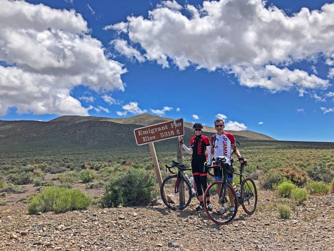
The pass is in the foothills in photo background.
John at the summit 2014 - bring lights as a precaution when riding in the desert.
Stacy and Bruce early 2019.
Summit September, 2019 . . . 😞
Be careful on this one as there is no support anywhere along the climb and, while you will encounter traffic along Hwy 190 up to the Emigrant Canyon Road turn off, you may not see another soul after that.
No way I am doing that Peter!
Spiders seriously creep me out!
We also saw a herd of mules and coyote along this climb.
Weather: Do NOT attempt these climbs in the summer when the average high temperatures range from 101-116 between May and September. (See Weather summary, below, for more details.
Traffic and Roadway report: As of October, 2014, the roadway surface was excellent throughout this ride but there is minimal to no shoulder and traffic can zoom by at highway speeds. Traffic after the turn off at Emigrant Canyon Road is effectively nonexistent.
WHERE TO STAY IN DEATH VALLEY
We have entered Death Valley both from the west (via Lone Pine Whitney Portal and Horseshoe Meadows; 50 miles to Panamint Springs) and Las Vegas (Kyle Canyon and Lee Canyon; 140 miles to Furnace Creek).
There are 3 areas with hotels in Death Valley:
Sign at Panamint Springs Resort
The birds to the left are real . . .
Entrance to Stovepipe Wells Village Hotel
Distance from Stovepipe Wells to all climbs.
Entrance to The Ranch at Death Valley
The Ranch at Death Valley has by far the nicest store in Death Valley
The only locations to get gas in Death Valley are at Panamint, Stovepipe and Furnace Creek - but, buyer beware:
The math on that is $5.99 per gallon (2014 prices; 2019 were slightly less)
DEATH VALLEY WEATHER
National Park Service Death Valley Weather Chart
Dangerously hot during the day from June through September with average monthly highs during that time ranging from 106 to 116.5. Cycling is not recommended during the summer and certainly never without good SAG support. The heat can be stifling (if not truly dangerous) and supplies are few and far between - there are none anywhere on this route - no water, no nothin . . .
The hottest temperature ever recorded on earth was in Furnace Creek on July 10, 1913 (134℉/56.7℃) and, while that record has been challenged, the “alternate” record is also held by Death Valley (2013 in a tie with Mitribah, Kuwait in 2016 at 129.2℉/54.0℃).
July 2017 - Badwater to Mt. Whitney Summit.
O.K.! I didn’t take my own advice in July, 2017 😨