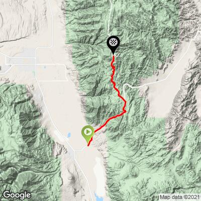
39.8
PDI
20.3 mi
DISTANCE
6,391 ft
GAINED
5.8 %
AVG. GRADE
FULL CLIMB STATS
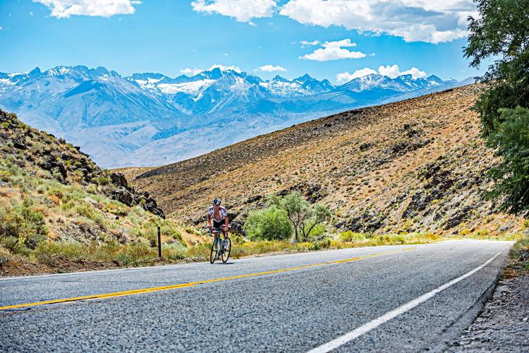
Photos By: Maxfield Bonta
Page Contributor(s): Luke Hise, Phoenix, AZ
INTRO
White Mountain is one of the great ones - an epic, scenic, long and challenging bike climb to the second highest paved points in California. This is one of the Big Four of the Owens Valley (although there are 10 HC in all) - White Mountain, Onion Valley Road, Whitney Portal Road, and Horseshoe Meadows Road. Half of this climb is on Highway 168 and the second half is on White Mountain Road where we have some spectacular views west of the Eastern Sierra Nevada Range over and across Owens Valley. White Mountain is the #3 ranked bike climb in California, #10 US and #105 World.
PLAN YOUR ROUTE
While this climb averages 5.8% for 20 miles, its true grade (after removing three sections of descent) is an even more challenging 6.6%. Compounding the challenge of this climb is that we lose 3% oxygen every 1,000' above sea level we travel - thus, at 10,000' we have 30% less oxygen than at sea level.
12% of this climb (2.5 combined miles) are at 10% grade or above. The steepest quarter mile is 10.7% (at 8,000') and the steepest mile 9.7% beginning at mile 14.6 on White Mountain Road.
Roadway: Highway 168 and White Mountain Road were in excellent condition as of 2019. For road conditions see Inyo County Road Open/Closed Status.
Traffic: Traffic for the first 10.5 miles on Highway 168 is light, but it does travel at Highway speeds and can be unnerving to the traffic adverse cyclist. Traffic is very mild and no problem at all for the remaining 10 miles on White Mountain Road. For those with a fear of highway traffic, you may consider beginning the climb at the start of White Mountain Road - that alone is a big challenge at 9.6 miles gaining 3,023' at 5.6% average grade from 7,300 to 10,000' elevation.
Parking: We normally park at the start of the climb - the intersection of Highway 168 and Death Valley Road - Map; Street View.
You finish the climb over 6,000' higher than you start, so be sure to check the PJAMM weather tool for the forecast at the top around the time you finish and bring gear as indicated by expected weather conditions.
Note: Check weather conditions with the Inyo National Forest Service for each climb you intend to do and the Inyo County road conditions website before traveling to Owens Valley to cycle anytime after September or before June.
Owens Valley county road conditions: https://www.inyocounty.us/services/public-works/news/inyo-county-road-openclosed-status
Owens Valley State Highways and roads maintained by CDOT status : https://roads.dot.ca.gov/
Before heading out on any cycling adventure check out our Things to Bring on a Cycling Trip and use our interactive check list to ensure you don't forget anything.
Be sure to do the wonderful Methuselah Trail hike out of Schulman Grove Visitor Center at mile 21 of our bike ride - AllTrails Methuselah Trail hike - 4 miles gaining 761'. Spend some time at the Visitor Center (Google Map + Reviews) and Patriarch Grove at mile 12 miles past Schulman Grove VC (the grove is about a mile off the "main" road - Route map; Google Map + Reviews) - note, this is a dirt road, but manageable on a road bike with, preferably, 28-30mm tires. Don't miss out on pastries at Schat's next to the Creekside Inn.
Owen's Valley has the greatest concentration of HC climbs in the US and is one of the greatest climbing areas in the world (Owen's Valley, CA climb area)
ROUTE MAP
MEMBER RATING
CURRENT WEATHER
PJAMM TRIPS ADVENTURE STARTER BUNDLES
Check out PJAMM Adventure's prepackaged (self-guided) cycling trips. They will help you plan, document and conquer your next adventure.
NEARBY CLIMBS (0) RADIAL PROXIMITY
FROM No Climbs Found
MEMBER REVIEWS & COMMENTS
Let us know what you thought of this climb. Signup for our FREE membership to write a review or post a comment.
Already have an account?
LOG IN HERE
Jcbikeboy
It is absolutely harder than Onion Valley. Ive done multiple ascents of Onion Valley twice, and never even considered it on white mtn. The descent ,however, of white mtn is very underrated. It isnt super technical( though wind is often formidable), but if you like going fast for a LONG time then this is hard to beat. Truly one of my favorite mountains to ride anywhere!
Skotscott
Sept 9, 2023
All the comments and pjamm say enough about this climb. I parked on the paved lot on the right at the info kiosk at the start of hwy 168 - easy 2.3 mile warmup ride to the pjamm start. It is a wonderfully hard, long, grind up and up to the visitors center (short downhill to the vc). Bottled water available. The climb up 168 was a bit unnerving with no shoulder and 55mph. Some steep sections and lots of curves so the traffic was slowed in areas. Very little traffic on White Mountain Rd. WMR was a bit lumpy on the way down and lots of loose gravel so good brakes are necessary. Decending on 168 was great - full speed on a decent road.
I do think this climb was just as hard as the Onion Valley rd climb. They are 2 different climbs - both hard but different.
UltimateExposure
White Mountain is a long climb and gave us a good run for our money towards the end. It starts off with small gradients then starts to work it's way up around mile 2. From there you won't get much under a 7% grade until mile 8. It will through you a nice easy, what feels almost flat, for about 1 mile then will tease you with a few short up hill battles then levels off just shy of mile 10. That will feel like a breeze and will take you to White Mountain Road, where you'll take a left on and do another 5 miles fluctuating in altitude of 7,000 and 8,000 feet. Once you hit the 15 mile marker, it's game on. The road will through steep climbs at you and test your lungs, but the views get amazing towards the end of this climb. You will get stunning views of the Sierra Mountain range as you push through the last few miles. It will help you take you mind off the slow burning pain you'll be experiencing as the gradient easily gets over 10%. Overall, this climb is a long, tough, a climb that will
Chaddad

Of the Owens Valley big 4, White Mountain is the most irregular grade and has the most descents. Don't be in a hurry pushing through the bottom because you are going to need plenty of power to get through the last three steep miles at nearly ten thousand feet. The lower climb is nothing to write home about, but the last three miles make it worth it with a spectacular view of the mountains on the other side of the valley. As for White Mountain vs. Onion Valley Road vs Horseshoe Meadows, , it depends on what you consider harder. WM is very irregular and steep in sections but there is always a break after a bit. OVR is an incessant, 8-9 percent grind for the last ten miles. HM is really long but the hardest part is down lower. Pick your pain. Add in Glacier Lodge on the other side of the valley first for an epic 10,000 ft climbing day. This is the perfect climb for my big tire road bike. Keep it real on the upper descent; there are roots and rough sections that can launch you.
lirizar1
I would argue this is the hardest climb in the area rather than onion valley. It is longer and steeper just happens to have a flat and downhill section in the middle. It is externally hot on this climb with the sun beating down on you almost the entire climb and constant steep pitches. Nice views with limited traffic. I would definitely recommend if in the area.
BradButterfield
One of the USA's finest. Summer and fall are sweltering in the Valley, but as you climb the 7,000 feet up the temps become comfortable and the views are incredible. The day I did it was 105 degrees at the base and 70 up top. The Ancient Bristlecone Pine forest is at the summit - home to some of the oldest trees in the world, and some long abandoned mines/ miner's cabins. Grandview campground is a few miles from the summit and is a great place to camp for the night.
jsummers
White Mountain is a giant, two solid climbs in a sense with a flatter section in between. The single lane section is unique, just keep an ear open for traffic. The initial section is a fun descent as well. Certainly worth the effort to get there,


